1940s Maps of Rhea County, Tennessee
Explore 19 historic maps of Rhea County from the 1940s. These maps offer a rare glimpse into what life looked like during the 1940s — showing old roads, neighborhoods, homes, and landmarks that have changed or disappeared over time.
Whether you're researching your family's past, planning a metal detecting trip, or studying how Rhea County's landscape evolved across the 1940s, these high-resolution maps are a powerful tool for exploring the history of this region.
- Focus on a specific era: All maps on this page are from the 1940s, giving you a focused view of this time period.
- See what’s changed: Compare century-old streets, trails, and buildings to today's modern landscape using overlays and satellite layers.
- Research with precision: Use these maps for genealogy, historical research, land use analysis, or educational projects.
- View, download, or print: Maps are fully viewable online in high resolution, and can be downloaded or printed for your own records.
Start exploring Rhea County's history through authentic maps from the 1940s. This is your window into the past.
Rhea County, TN maps
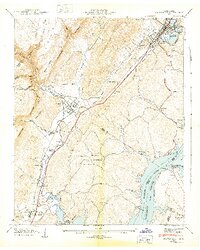
(19)- 1940 Map of Rockwood
 1940 Rockwood1940 Print · USGSThe Tennessee River valley at Rockwood is shown here during the transition to the reservoir era in the early 1940s. Genealogists can locate family sites like Odd Fellows Cem, trace the railroad to Glen Alice, or find old schools like New Hope Sch.
 - 1940 Map of Spring City
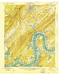
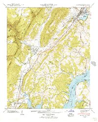
 1940 Spring City1940 Print · USGSRhea County at the start of the 1940s captures a landscape on the brink of transformation as the Watts Bar Reservoir prepared to flood the valley. Genealogists and historians can trace soon-to-be-submerged sites like Rhea Springs and Mc Elwee Landing, or explore the upland reaches of Grandview and Gum Gap.2 unique versions available
 - 1940 Map of Ten Mile
 1940 Ten Mile1940 Print · USGSMeigs and Roane counties are captured here just as the Tennessee Valley Authority was transforming the river landscape. Genealogists and local historians can trace rural family life through markers like Deatherage Cem, Euchee Sch, and the settlement at Ten Mile.
 - 1942 Map of Big Spring
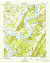
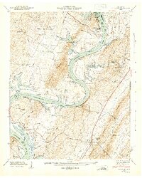
 1942 Big Spring1942 Print · USGSThe Tennessee and Hiwassee Rivers meet in the early 1940s, revealing a landscape of reservoir development and deep-rooted farm communities. Genealogists can locate Big Spring and family sites like Shaver Cem, while historians can trace the Cotton Port Ferry.
 - 1942 Map of Evensville, 1946 Print
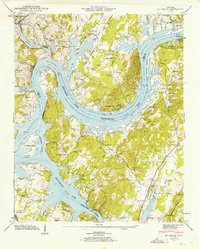
 1942 Evensville1946 Print · USGSRhea County is captured here in the early 1940s as the Tennessee Valley Authority projects reshaped the river landscape. Genealogists can trace family names through dozens of landmarks, including Washington Ferry, Smyrna Ch, and the Montgomery Cem.3 unique versions available
 - 1942 Map of Graysville, 1956 Print
 1942 Graysville1956 Print · USGSRhea County and the Tennessee River valley appear here in the early 1940s as newly formed reservoirs altered the landscape. Researchers can trace the historic Blythe Ferry crossing and find long-established local sites like New Providence Sch and the Old Browder Cem.2 unique versions available
 - 1942 Map of Goodfield, 1960 Print
 1942 Goodfield1960 Print · USGSThe Tennessee River valley and its surrounding ridges come alive in this wartime survey of Meigs and Rhea counties. Researchers can pinpoint several family burial grounds like Howser Cem and rural centers including Goodfield and Shiloh Sch.
 - 1942 Map of Decatur, 1962 Print
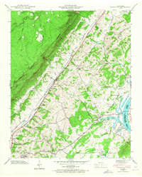
 1942 Decatur1962 Print · USGSMeigs County at the dawn of the hydroelectric era shows the Tennessee River transitioning into a reservoir system. Genealogists can trace family-named sites like Johns Chapel and Old Goodfield Cem near the newly formed Chickamauga Lake.2 unique versions available
 - 1943 Map of Graysville
 1943 Graysville1943 Print · USGSEast Tennessee at the dawn of the 1940s reveals a landscape of ridge-and-valley settlements tied to the river and rail. Genealogists can trace family names through the Graysville Cem, New Providence Sch, and numerous churches like Garrison Ch.2 unique versions available
 - 1943 Map of Goodfield, 1946 Print
 1943 Goodfield1946 Print · USGSMeigs County in the early 1940s reveals a landscape of ridge-and-valley farming communities just as the newly formed reservoir was reshaping the riverfront. Genealogists can locate family landmarks like Cox Cem, Allen Store, and the rural Shiloh Sch.
 - 1943 Map of Decatur, 1946 Print
 1943 Decatur1946 Print · USGSMeigs County was undergoing a massive transformation in the early 1940s as the Tennessee River was harnessed for power and navigation. Researchers can locate dozens of ancestral sites, from Kings Mill and Pinhook Ferry to rural schools like Fairview Sch.
 - 1943 Map of Big Spring, 1946 Print
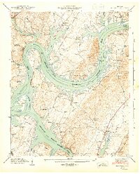 1943 Big Spring1946 Print · USGSThe Tennessee River valley in the early 1940s reveals a landscape reshaped by the newly formed Chickamauga Reservoir. Genealogists and local historians can trace family land near Big Spring, the Cotton Port Ferry, and numerous country churches like Burkett Chapel.2 unique versions available
 - 1946 Map of Roddy, 1960 Print
 1946 Roddy1960 Print · USGSThe Cumberland Plateau meets the Tennessee Valley just after the war, where rail lines and ridgeline gaps defined local travel. Researchers can trace family sites like Williams Cem or follow the old tracks of the Tennessee Central Railroad near Roddy.2 unique versions available
 - 1946 Map of Brayton, 1960 Print
 1946 Brayton1960 Print · USGSThe rugged Cumberland Plateau comes to life in this mid-century look at Bledsoe and Rhea counties. Researchers can trace family history through sites like Hendon Cem, the community of Smithtown, and the remote Brayton Church.2 unique versions available
 - 1946 Map of Grassy Cove, 1968 Print
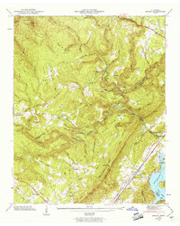
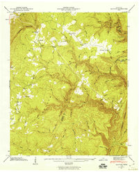
 1946 Grassy Cove1968 Print · USGSThe high Cumberland Plateau in the late 1940s reveals a landscape of massive karst depressions and isolated mountain settlements. Genealogists and hikers can trace old family sites like Reed Cem, landmarks such as Milksick Cave, and the rural community of Alloway.
 - 1947 Map of Brayton
 1947 Brayton1947 Print · USGSBledsoe County plateau life and the Cumberland mountains are captured in detail just after the war. Local historians can trace family locations near Hendon, Smithtown, and the Hendon Cem, or locate landmarks like the Lookout Tower atop Walden Ridge.2 unique versions available
 - 1947 Map of Roddy, 1948 Print
 1947 Roddy1948 Print · USGSThe Cumberland Escarpment and Watts Bar Reservoir define this 1940s landscape on the borders of Rhea and Roane counties. Genealogists can trace family names at Williams Cem, locate the Big Sandy Sch, and find the old Gibson Inn.
 - 1949 Map of Grassy Cove
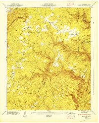
 1949 Grassy Cove1949 Print · USGSUpper East Tennessee's mountain landscape is shown here in the late 1940s, centered on the unique geologic sink of Grassy Cove. Family historians can trace rural roots at Alloway Ch, Reed Cem, and the high-elevation community of Jewett.
 - 1949 Map of Pennine
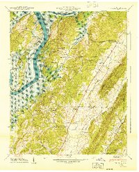
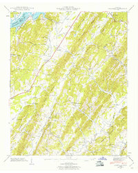
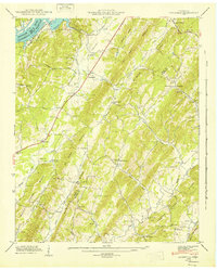
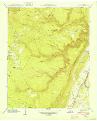 1949 Pennine1949 Print · USGSRhea County at the close of the 1940s reveals a landscape defined by the Cumberland Escarpment and the Southern rail line. Genealogists can locate family-named sites like De Vaney Cem and Thurman Cem, or trace the path of Stinging Fork Falls.
End of results
Showing maps 1-19 of 19
Top cities of Rhea County
Frequently asked questions
- What are the different types of historical maps available for Rhea County?
- What is the oldest map of Rhea County?
- Where can I purchase historical maps of Rhea County for my home or office?
- Where can I download high-res historical maps of Rhea County?
- Are there historical topographic maps available for Rhea County?
- Is there historical aerial imagery available for Rhea County?
- Where are historical maps of Rhea County sourced from?