1940 Map of Rockwood
USGS Topo · Published 1940About this map
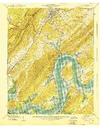
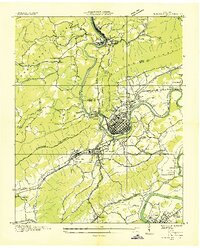
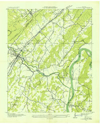
Rockwood sits at the base of the Cumberland Escarpment, where the Southern railroad line follows the valley floor toward Westel. This 1940 preliminary edition captures the landscape as the Watts Bar Reservoir began to alter the course of the Tennessee River. The river winds around Thief Neck and past Half Moon Island, marking the boundaries between Roane, Rhea, and Meigs counties. On the higher ground of Walden Ridge, the Mt Roosevelt Lookout Tower overlooks a network of rural communities defined by landmarks like The Tabernacle and Eureka Chapel. Small industrial and agricultural sites are scattered throughout, including Eagle Furnace and Rockwood Landing, reflecting an era of river-based commerce and early mountain industry before modern infrastructure reshaped the valley's character.
Find a feature on this map
82 named features on this map. Tap any name to fly to it.
Don’t see what you’re looking for? This feature index may not catch every label — zoom into the map to look around manually.
Map Details
Editions of this 1940 Rockwood Map
This is the sole edition of this map. No revisions or reprints were ever made.
Other maps of this area

1887 · Kingston
USGS Topo · 1:125,000

1891 · Kingston
USGS Topo · 1:125,000

1893 · Kingston
USGS Topo · 1:125,000

1935 · Rockwood
USGS Topo · 1:24,000
1935 · Harriman
USGS Topo · 1:24,000

1936 · Roddy
USGS Topo · 1:24,000

1936 · Ozone
USGS Topo · 1:24,000

1936 · Cardiff
USGS Topo · 1:24,000
1936 · Spring City
USGS Topo · 1:24,000

1936 · Pattie Gap
USGS Topo · 1:24,000