
1935 Map of Rockwood
USGS Topo · Published 1935About this map
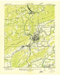
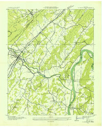
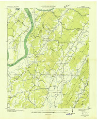
The industrial and community hub of Rockwood anchors this mid-1930s survey, situated where the Tennessee Central Railroad and Southern Railway meet the base of the Walden Ridge. The landscape is characterized by a dense network of social institutions, including The Tabernacle, Asbury Chapel, and Possum Trot Ch. Education is similarly decentralized across several rural facilities such as Hopewell Sch and Glen Alice Sch. To the southeast, the Tennessee River winds through the terrain, creating geographical features like Thief Neck and Moon Island. The presence of the Rockwood Pumping Station and Rockwood Landing indicates the town's reliance on both rail and water infrastructure. Elevated landmarks, notably the Mt Roosevelt Fire Tower on the Cumberland Escarpment, overlook the transition from the rugged ridge to the lower Abell Valley.
Find a feature on this map
63 named features on this map. Tap any name to fly to it.
Don’t see what you’re looking for? This feature index may not catch every label — zoom into the map to look around manually.
Map Details
Editions of this 1935 Rockwood Map
This is the sole edition of this map. No revisions or reprints were ever made.
Other maps of this area

1887 · Kingston
USGS Topo · 1:125,000

1891 · Kingston
USGS Topo · 1:125,000

1893 · Kingston
USGS Topo · 1:125,000
1935 · Harriman
USGS Topo · 1:24,000

1936 · Roddy
USGS Topo · 1:24,000

1936 · Ozone
USGS Topo · 1:24,000

1936 · Cardiff
USGS Topo · 1:24,000
1936 · Spring City
USGS Topo · 1:24,000

1936 · Pattie Gap
USGS Topo · 1:24,000
1936 · Ten Mile
USGS Topo · 1:24,000