1970s Maps of Reid Camp, Tennessee
Explore 3 historic maps of Reid Camp from the 1970s. These maps offer a rare glimpse into what life looked like during the 1970s — showing old roads, neighborhoods, homes, and landmarks that have changed or disappeared over time.
Whether you're researching your family's past, planning a metal detecting trip, or studying how Reid Camp's landscape evolved across the 1970s, these high-resolution maps are a powerful tool for exploring the history of this region.
- Focus on a specific era: All maps on this page are from the 1970s, giving you a focused view of this time period.
- See what’s changed: Compare century-old streets, trails, and buildings to today's modern landscape using overlays and satellite layers.
- Research with precision: Use these maps for genealogy, historical research, land use analysis, or educational projects.
- View, download, or print: Maps are fully viewable online in high resolution, and can be downloaded or printed for your own records.
Start exploring Reid Camp's history through authentic maps from the 1970s. This is your window into the past.
Reid Camp, TN maps
- 1973 Map of Roddy, 1974 Print
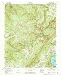 1973 Roddy1974 Print · USGSThe Cumberland Escarpment meets the waters of Watts Bar Lake in the early seventies, where rail lines and highways navigate the gaps of Walden Ridge. Genealogists can trace family names at Dogwood Cem and Kelley Cem or locate the quiet grounds of Johnson Chapel.3 unique versions available
End of results
Showing maps 1-1
Top cities near Reid Camp
- Fairfield Glade historical maps
- Kingston historical maps
- Harriman historical maps
- Sweetwater historical maps
- Rockwood historical maps
- Spring City historical maps
See more
Frequently asked questions
- What are the different types of historical maps available for Reid Camp?
- What is the oldest map of Reid Camp?
- Where can I purchase historical maps of Reid Camp for my home or office?
- Where can I download high-res historical maps of Reid Camp?
- Are there historical topographic maps available for Reid Camp?
- Is there historical aerial imagery available for Reid Camp?
- Where are historical maps of Reid Camp sourced from?