1930s Maps of Oakleigh Estates, Walnut Hill
Explore 4 historic maps of Oakleigh Estates from the 1930s. These maps offer a rare glimpse into what life looked like during the 1930s — showing old roads, neighborhoods, homes, and landmarks that have changed or disappeared over time.
Whether you're researching your family's past, planning a metal detecting trip, or studying how Oakleigh Estates's landscape evolved across the 1930s, these high-resolution maps are a powerful tool for exploring the history of this region.
- Focus on a specific era: All maps on this page are from the 1930s, giving you a focused view of this time period.
- See what’s changed: Compare century-old streets, trails, and buildings to today's modern landscape using overlays and satellite layers.
- Research with precision: Use these maps for genealogy, historical research, land use analysis, or educational projects.
- View, download, or print: Maps are fully viewable online in high resolution, and can be downloaded or printed for your own records.
Start exploring Oakleigh Estates's history through authentic maps from the 1930s. This is your window into the past.
Oakleigh Estates, Walnut Hill maps
(4)- 1935 Map of Blountville
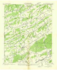 1935 Blountville1935 Print · USGSSullivan County and the Virginia borderlands are documented here in the mid-1930s, showing a rural landscape organized around the county seat and mountain ridges. Genealogists can trace family locations near Hickory Grove Sch, Linville Cave, and the Sullivan County Farm.2 unique versions available
 - 1935 Map of Mages
 1935 Mages1935 Print · USGSThe Tennessee-Virginia borderlands appear here in the mid-1930s, showing a landscape of ridge-and-valley settlements and rural crossroads. Researchers can locate numerous family-centered sites including Pyles Cem, St Joseph Ch, and Mill Point.
 - 1938 Map of Blountville, 1954 Print
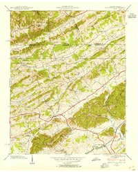 1938 Blountville1954 Print · USGSSullivan County and the Virginia borderlands are captured here in the late thirties as a network of ridge-top schools and valley churches. Genealogists can trace family landmarks like the Latture Cem, Fraley Institute, and the local County Farm.
 - 1939 Map of Blountville
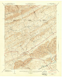 1939 Blountville1939 Print · USGSSullivan County near the Virginia border is captured here in the late thirties, centered on the historic seat of Blountville. Researchers can locate family landmarks such as Latture Cem, Fraley Institute, and numerous rural schoolhouses like Oakview Sch.2 unique versions available
End of results
Showing maps 1-4 of 4
Frequently asked questions
- What are the different types of historical maps available for Oakleigh Estates?
- What is the oldest map of Oakleigh Estates?
- Where can I purchase historical maps of Oakleigh Estates for my home or office?
- Where can I download high-res historical maps of Oakleigh Estates?
- Are there historical topographic maps available for Oakleigh Estates?
- Is there historical aerial imagery available for Oakleigh Estates?
- Where are historical maps of Oakleigh Estates sourced from?