
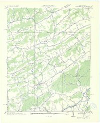
1935 Map of Blountville
USGS Topo · Published 1935About this map
The Appalachian Valley landscape of Sullivan County is captured here in the mid-1930s, centered on the seat of Blountville. The Tennessee Valley Authority and USGS mapped this terrain as the region's rural infrastructure was expanding, showing a network of schools and churches that served as community anchors, such as Oakview Sch and Pleasant Hill Ch. The map details a transition from traditional land use to early industrial footprints, including an Oil Mill and the East Tenn Light and Power Co Transmission Line.
Find a feature on this map
57 named features on this map. Tap any name to fly to it.
Don’t see what you’re looking for? This feature index may not catch every label — zoom into the map to look around manually.
Map Details
Editions of this 1935 Blountville Map
2 editions found
Other maps of this area

1891 · Roan Mountain
USGS Topo · 1:125,000

1894 · Roan Mountain
USGS Topo · 1:125,000

1897 · Bristol
USGS Topo · 1:125,000

1902 · Bristol
USGS Topo · 1:125,000

1904 · Roan Mountain
USGS Topo · 1:125,000

1934 · Wallace
USGS Topo · 1:24,000

1934 · Bristol
USGS Topo · 1:24,000

1935 · Hilton
USGS Topo · 1:24,000

1935 · Watauga Valley
USGS Topo · 1:48,000

1935 · Mendota
USGS Topo · 1:24,000