
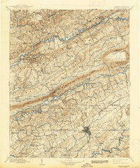
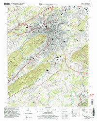
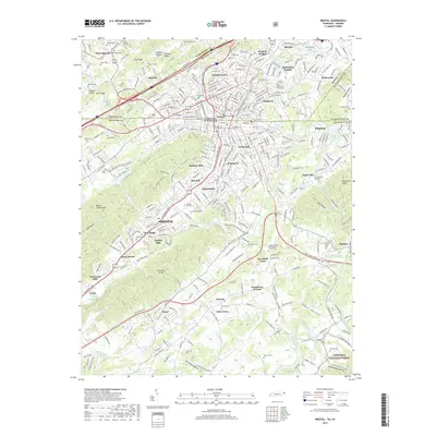
1897 Map of Bristol
USGS Topo · Published 1897About this map
The Bristol area, straddling the state boundary during the late nineteenth century, is defined by a dense network of parallel ridges including Clinch Mountain, Copper Ridge, and Moccasin Ridge. This topography dictated the development of the region, funneling transport along narrow corridors like Poor Valley and Preston Valley. The Norfolk and Western RR and the Southern RR navigate these gaps to connect early industrial and agricultural hubs. Local commerce is anchored by family-operated sites such as Bickley Mill, Jessees Mills, and Masons Store, while mining activity is evident at Ore Bank near Indian Springs. The Holston River and Moccasin Creek provide the primary drainage for this complex landscape, with Childress Ferry providing a vital crossing point. Small settlements like Castlewood, Dickensonville, and Lebanon are shown in their early configurations, offering a detailed view of Appalachian settlement patterns before modern highway expansion transformed the Tennessee-Virginia border.
Find a feature on this map
162 named features on this map. Tap any name to fly to it.
Don’t see what you’re looking for? This feature index may not catch every label — zoom into the map to look around manually.
Map Details
Editions of this 1897 Bristol Map
This is the sole edition of this map. No revisions or reprints were ever made.
Historical Maps of Kingsport Through Time
12 maps found
1897 Bristol
Sullivan County, TN
1902 Bristol
Sullivan County, TN
1934 Bristol
Sullivan County, TN
1938 Bristol
Sullivan County, TN
1959 Bristol
Sullivan County, TN

1981 Bristol
Sullivan County, TN
2003 Bristol
Sullivan County, TN
2011 Bristol
Sullivan County, TN
2013 Bristol
Sullivan County, TN
2016 Bristol
Sullivan County, TN
2019 Bristol
Sullivan County, TN
2022 Bristol
Sullivan County, TN