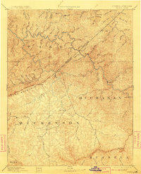
1890 Map of Grundy
USGS Topo · Published 1890About this map
Grundy and the surrounding central Appalachian highlands appear here during a late 19th-century survey conducted under Director J.W. Powell. The terrain is dominated by the intricate drainage systems of Russell Fork and the Pound River, which carve through the steep ridges of Pine Mountain. This early topography reflects a landscape of dispersed mountain settlements and essential river crossings, such as Fish Trap and Jamboree, before the arrival of heavy industrial rail or coal infrastructure. Notable topographical landmarks include The Breaks, a dramatic canyon where the river cuts through the mountain range near the Kentucky Virginia Boundary Line. The map also captures early county seats and crossroads like Clintwood and Sand Lick, offering a view of the region's isolated social geography and the natural gateways that defined movement through Buchanan and Dickenson counties.
Find a feature on this map
69 named features on this map. Tap any name to fly to it.
Don’t see what you’re looking for? This feature index may not catch every label — zoom into the map to look around manually.
Map Details
Editions of this 1890 Grundy Map
This is the sole edition of this map. No revisions or reprints were ever made.
Historical Maps of Pikeville Through Time
5 maps found