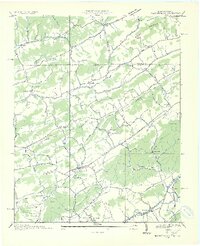
1935 Map of Blountville
USGS Topo · Published 1935About this map
Blountville serves as the focal point of this 1935 Tennessee Valley Authority and USGS collaboration, capturing the crossroads of Upper East Tennessee just before the mid-century expansion. The landscape is defined by its deep community roots, evidenced by the high density of rural institutions like the Fraley Institute, Reedy Creek Sch, and Emmanuel Ch. The terrain transitions from the slopes of Walker Mountain in the north down toward the Beaver Creek drainage, where the Southern Railway passes through Earheart. Notably, the presence of the Sullivan County Farm and numerous hollows such as Ross Hollow and Mc Clellan Hollow illustrates a deeply carved agricultural and social geography. Transportation routes including U S Highway No 11 W No 11 E and various electric transmission lines reflect the early stages of the region's modernization and electrification during the New Deal era.
Find a feature on this map
66 named features on this map. Tap any name to fly to it.
Don’t see what you’re looking for? This feature index may not catch every label — zoom into the map to look around manually.
Map Details
Editions of this 1935 Blountville Map
2 editions found

Other maps of this area

1891 · Roan Mountain
USGS Topo · 1:125,000

1894 · Roan Mountain
USGS Topo · 1:125,000

1897 · Bristol
USGS Topo · 1:125,000

1902 · Bristol
USGS Topo · 1:125,000

1904 · Roan Mountain
USGS Topo · 1:125,000

1934 · Wallace
USGS Topo · 1:24,000

1934 · Bristol
USGS Topo · 1:24,000

1935 · Hilton
USGS Topo · 1:24,000

1935 · Watauga Valley
USGS Topo · 1:48,000

1935 · Mendota
USGS Topo · 1:24,000