1940s Maps of Unicoi County, Tennessee
Explore 3 historic maps of Unicoi County from the 1940s. These maps offer a rare glimpse into what life looked like during the 1940s — showing old roads, neighborhoods, homes, and landmarks that have changed or disappeared over time.
Whether you're researching your family's past, planning a metal detecting trip, or studying how Unicoi County's landscape evolved across the 1940s, these high-resolution maps are a powerful tool for exploring the history of this region.
- Focus on a specific era: All maps on this page are from the 1940s, giving you a focused view of this time period.
- See what’s changed: Compare century-old streets, trails, and buildings to today's modern landscape using overlays and satellite layers.
- Research with precision: Use these maps for genealogy, historical research, land use analysis, or educational projects.
- View, download, or print: Maps are fully viewable online in high resolution, and can be downloaded or printed for your own records.
Start exploring Unicoi County's history through authentic maps from the 1940s. This is your window into the past.
Unicoi County, TN maps
(3)- 1940 Map of Sams Gap
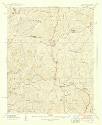 1940 Sams Gap1940 Print · USGSThe high ridges of Madison County were still dominated by small-scale farming and forest life when this survey was completed. Genealogists can trace family footprints across Sams Gap through landmarks like the Robinson Cem, Higgins Chapel, and Halls Store.
 - 1940 Map of Johnson City
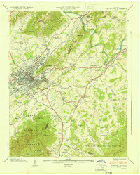 1940 Johnson City1940 Print · USGSJohnson City and its surrounding valleys are captured here at the start of the 1940s, showing a vital rail junction and industrial center. Genealogists can locate family landmarks like Taylor Chapel Cem, Milligan College, and the National Soldiers Home.2 unique versions available
 - 1940 Map of Chestoa
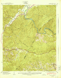 1940 Chestoa1940 Print · USGSThe Tennessee and North Carolina borderlands come alive in the late 1930s, where the river and rail cut through the Unaka range. Researchers can trace the Clinchfield RR corridor through mountain hamlets like Chestoa, Unaka Springs, and the isolated Lost Cove.
End of results
Showing maps 1-3 of 3
Top cities of Unicoi County
Frequently asked questions
- What are the different types of historical maps available for Unicoi County?
- What is the oldest map of Unicoi County?
- Where can I purchase historical maps of Unicoi County for my home or office?
- Where can I download high-res historical maps of Unicoi County?
- Are there historical topographic maps available for Unicoi County?
- Is there historical aerial imagery available for Unicoi County?
- Where are historical maps of Unicoi County sourced from?