1930s Maps of Rocky Fork, Tennessee
Explore 2 historic maps of Rocky Fork from the 1930s. These maps offer a rare glimpse into what life looked like during the 1930s — showing old roads, neighborhoods, homes, and landmarks that have changed or disappeared over time.
Whether you're researching your family's past, planning a metal detecting trip, or studying how Rocky Fork's landscape evolved across the 1930s, these high-resolution maps are a powerful tool for exploring the history of this region.
- Focus on a specific era: All maps on this page are from the 1930s, giving you a focused view of this time period.
- See what’s changed: Compare century-old streets, trails, and buildings to today's modern landscape using overlays and satellite layers.
- Research with precision: Use these maps for genealogy, historical research, land use analysis, or educational projects.
- View, download, or print: Maps are fully viewable online in high resolution, and can be downloaded or printed for your own records.
Start exploring Rocky Fork's history through authentic maps from the 1930s. This is your window into the past.
Rocky Fork, TN maps
(2)- 1936 Map of Flag Pond
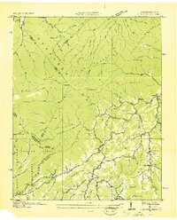 1936 Flag Pond1936 Print · USGSThe Tennessee and North Carolina borderlands come alive in the mid-1930s, showing a landscape of high ridges and secluded valley settlements. Researchers can trace the original path of the Appalachian Trail past family landmarks like Harris Mill and the Clearbranch Post Office.
 - 1939 Map of Flag Pond
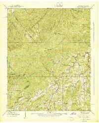 1939 Flag Pond1939 Print · USGSThe Unicoi County mountains at the end of the 1930s reveal a landscape of high-altitude settlements and family-named ridges. Researchers can trace the early Appalachian Trail route past Flag Pond, Harris Mill, and rural sites like Sams Cem.3 unique versions available
End of results
Showing maps 1-2 of 2
Top cities near Rocky Fork
- Johnson City historical maps
- Greeneville historical maps
- Erwin historical maps
- Unicoi historical maps
- Tusculum historical maps
- Mars Hill historical maps
See more
Frequently asked questions
- What are the different types of historical maps available for Rocky Fork?
- What is the oldest map of Rocky Fork?
- Where can I purchase historical maps of Rocky Fork for my home or office?
- Where can I download high-res historical maps of Rocky Fork?
- Are there historical topographic maps available for Rocky Fork?
- Is there historical aerial imagery available for Rocky Fork?
- Where are historical maps of Rocky Fork sourced from?