1950s Maps of Warren County, Tennessee
Explore 9 historic maps of Warren County from the 1950s. These maps offer a rare glimpse into what life looked like during the 1950s — showing old roads, neighborhoods, homes, and landmarks that have changed or disappeared over time.
Whether you're researching your family's past, planning a metal detecting trip, or studying how Warren County's landscape evolved across the 1950s, these high-resolution maps are a powerful tool for exploring the history of this region.
- Focus on a specific era: All maps on this page are from the 1950s, giving you a focused view of this time period.
- See what’s changed: Compare century-old streets, trails, and buildings to today's modern landscape using overlays and satellite layers.
- Research with precision: Use these maps for genealogy, historical research, land use analysis, or educational projects.
- View, download, or print: Maps are fully viewable online in high resolution, and can be downloaded or printed for your own records.
Start exploring Warren County's history through authentic maps from the 1950s. This is your window into the past.
Warren County, TN maps
(9)- 1952 Map of Centertown, 1957 Print
 1952 Centertown1957 Print · USGSMid-century Hickman County is defined here by the winding Duck River and the industrial activity of the Nunnelly Mines. Researchers can trace the path of the Goodrich Railroad or locate local landmarks like Grinders Switch and Bell Branch Sch.2 unique versions available
 - 1953 Map of Chattanooga
 1953 Chattanooga1953 Print · USGSSoutheast Tennessee in the early fifties shows a landscape reshaped by river management and rail power. Trace the rail lines of the Southern Ry through riverside towns or locate the preserved grounds of the Chickamauga and Chattanooga National Military Park.
 - 1953 Map of Centertown, 1955 Print
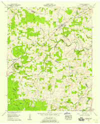
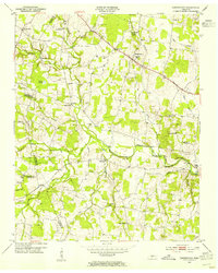 1953 Centertown1955 Print · USGSWarren and Cannon counties are captured in the early 1950s as rural agricultural life followed the N C & St L railroad and the Broadway of America. Researchers can locate numerous family-named landmarks, from the Poor House Cem to Grange Hall Chapel and Trousdale.4 unique versions available
 - 1953 Map of Mc Minnville, 1955 Print
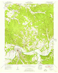
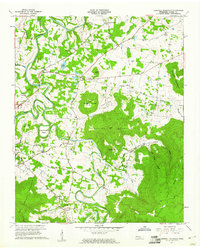
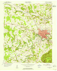 1953 Mc Minnville1955 Print · USGSWarren County in the mid-fifties centers on the riverside growth of Mc Minnville and the rugged heights of Ben Lomond Mountain. Genealogists can trace family names through landmarks like Faulkner Springs, Finger Chapel Ch, and Lawson Mill.4 unique versions available
 - 1955 Map of Viola, 1956 Print
 1955 Viola1956 Print · USGSViola and the surrounding valleys of the Highland Rim are captured here in the mid-fifties, showing the region's agricultural and social layout. Researchers can trace family sites at Vervilla, Rockcliff Ch, and Northeutts Cove Sch.2 unique versions available
 - 1956 Map of Morrison, 1958 Print
 1956 Morrison1958 Print · USGSWarren and Coffee counties appear here in the mid-fifties as the railroad corridor through Morrison and Summitville shaped local commerce. Genealogists can trace family names through rural burial sites like Richard Cem and the industrial history at Bryan Mill.3 unique versions available
 - 1957 Map of Cardwell Mountain, 1961 Print
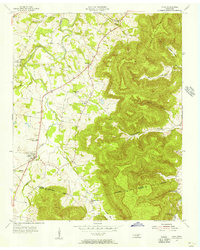
 1957 Cardwell Mountain1961 Print · USGSWarren County in the late fifties was a landscape of dramatic river bends and prominent peaks like Cardwell Mountain. Genealogists and historians can trace family ties at Higgenbottom Cem, Mt Vernon Ch, and the old rail stop at Rowland Station.5 unique versions available
 - 1957 Map of Chattanooga, 1966 Print
 1957 Chattanooga1966 Print · USGSEast Tennessee in the mid-1960s shows a landscape of massive hydroelectric reservoirs and emerging industrial sites like the Atomic Energy Commission (Oak Ridge Area). Trace the rail networks of the Southern Ry through Chattanooga or locate family-named ridges across the Cumberland Plateau.3 unique versions available
 - 1959 Map of Chattanooga
 1959 Chattanooga1959 Print · USGSSoutheast Tennessee is shown here during a decade of industrial growth and hydroelectric development. Trace the regional rail networks of the Southern Ry and find landmark sites like Lookout Mountain, Fall Creek Falls State Park, and Chattanooga.
End of results
Showing maps 1-9 of 9
Top cities of Warren County
Frequently asked questions
- What are the different types of historical maps available for Warren County?
- What is the oldest map of Warren County?
- Where can I purchase historical maps of Warren County for my home or office?
- Where can I download high-res historical maps of Warren County?
- Are there historical topographic maps available for Warren County?
- Is there historical aerial imagery available for Warren County?
- Where are historical maps of Warren County sourced from?