1900s (20th Century) Maps of Waynesboro, Tennessee
Explore 7 historic maps of Waynesboro from the 1900s (20th Century). These maps offer a rare glimpse into what life looked like during the 1900s — showing old roads, neighborhoods, homes, and landmarks that have changed or disappeared over time.
Whether you're researching your family's past, planning a metal detecting trip, or studying how Waynesboro's landscape evolved across the 1900s, these high-resolution maps are a powerful tool for exploring the history of this region.
- Focus on a specific era: All maps on this page are from the 1900s, giving you a focused view of this time period.
- See what’s changed: Compare century-old streets, trails, and buildings to today's modern landscape using overlays and satellite layers.
- Research with precision: Use these maps for genealogy, historical research, land use analysis, or educational projects.
- View, download, or print: Maps are fully viewable online in high resolution, and can be downloaded or printed for your own records.
Start exploring Waynesboro's history through authentic maps from the 1900s. This is your window into the past.
Waynesboro, TN maps
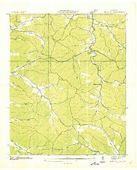
(7)- 1905 Map of Waynesboro
 1905 Waynesboro1905 Print · USGSWayne County and the Tennessee-Alabama borderlands are captured here at the start of the century, showing a network of river landings and old stage stands. Researchers can trace the Nathez Trace and locate historic community hubs like Martins Mills, Whittens Stand, and Clifton.2 unique versions available
 - 1936 Map of Negro Hollow
 1936 Negro Hollow1936 Print · USGSWayne County was characterized by its network of hollows and creek-side settlements during the mid-1930s. Genealogists can trace family landmarks and schools across this rural landscape, from Copeland Cem and Simmons to the Forty-eight Creek Sch.
 - 1936 Map of Waynesboro
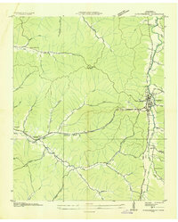 1936 Waynesboro1936 Print · USGSWaynesboro and the surrounding Wayne County hills are captured here in the mid-thirties as rural electrification began to transform the region. Genealogists can locate family landmarks like Morris Cem and Shields Cem or early schools including Lone Cedar Sch.
 - 1951 Map of Waynesboro, 1954 Print
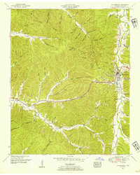 1951 Waynesboro1954 Print · USGSMid-century Wayne County is centered here at Waynesboro during a time of rural stability and emerging infrastructure. Researchers can trace family ties at Old Town Cem and Kee Cem, or locate landmarks like the Waynesboro Lookout Tower and Ray Sch.2 unique versions available
 - 1951 Map of Negro Hollow, 1954 Print
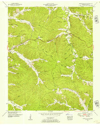 1951 Negro Hollow1954 Print · USGSWayne County, Tennessee, in the early fifties is mapped here as a labyrinth of namesake hollows and ridges. Genealogists and local historians can locate many family burial sites like Copeland Cem and Mt Hope Cem or trace the early path of the Natchez Trace Parkway.3 unique versions available
 - 1956 Map of Columbia, 1960 Print
 1956 Columbia1960 Print · USGSMiddle Tennessee in the mid-fifties presents a landscape of established river towns and critical rail hubs before the arrival of the modern interstate system. Researchers can trace the routes of the Louisville and Nashville railroad or locate historic landmarks like Stones River National Military Park and the Tennessee National Wildlife Refuge.6 unique versions available
 - 1985 Map of Lawrenceburg
 1985 Lawrenceburg1985 Print · USGSMiddle Tennessee and Northern Alabama are captured in the mid-1980s, showcasing a landscape of high ridges and winding river valleys. Genealogists and historians can trace rail lines like the Seaboard System Railroad or locate community landmarks such as Saint Marys Church and Three Churches.2 unique versions available
End of results
Showing maps 1-7 of 7
Top cities near Waynesboro
Frequently asked questions
- What are the different types of historical maps available for Waynesboro?
- What is the oldest map of Waynesboro?
- Where can I purchase historical maps of Waynesboro for my home or office?
- Where can I download high-res historical maps of Waynesboro?
- Are there historical topographic maps available for Waynesboro?
- Is there historical aerial imagery available for Waynesboro?
- Where are historical maps of Waynesboro sourced from?