1960s Maps of Luke Wilson, Texas
Explore 1 historic maps of Luke Wilson from the 1960s. These maps offer a rare glimpse into what life looked like during the 1960s — showing old roads, neighborhoods, homes, and landmarks that have changed or disappeared over time.
Whether you're researching your family's past, planning a metal detecting trip, or studying how Luke Wilson's landscape evolved across the 1960s, these high-resolution maps are a powerful tool for exploring the history of this region.
- Focus on a specific era: All maps on this page are from the 1960s, giving you a focused view of this time period.
- See what’s changed: Compare century-old streets, trails, and buildings to today's modern landscape using overlays and satellite layers.
- Research with precision: Use these maps for genealogy, historical research, land use analysis, or educational projects.
- View, download, or print: Maps are fully viewable online in high resolution, and can be downloaded or printed for your own records.
Start exploring Luke Wilson's history through authentic maps from the 1960s. This is your window into the past.
Luke Wilson, TX maps
(1)- 1963 Map of Archer City NE, 1964 Print
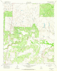 1963 Archer City NE1964 Print · USGSArcher County ranching and oil production are in full swing during the early sixties as the Little Wichita River cuts through the plains. Researchers can trace historic property boundaries like the Mule Shoe Ranch and the path of the Old Railroad Grade.
End of results
Showing maps 1-1 of 1
Top cities near Luke Wilson
- Wichita Falls historical maps
- Iowa Park historical maps
- Archer City historical maps
- Holliday historical maps
- Lakeside City historical maps
- Scotland historical maps
See more
Frequently asked questions
- What are the different types of historical maps available for Luke Wilson?
- What is the oldest map of Luke Wilson?
- Where can I purchase historical maps of Luke Wilson for my home or office?
- Where can I download high-res historical maps of Luke Wilson?
- Are there historical topographic maps available for Luke Wilson?
- Is there historical aerial imagery available for Luke Wilson?
- Where are historical maps of Luke Wilson sourced from?