Old Maps of Texas
Explore old maps of Texas, spanning from 1885 to today. These high-resolution historic maps reveal how streets, neighborhoods, landmarks, and natural features evolved over time — perfect for genealogy, metal detecting, research, and local history exploration.
What you can do with these maps:
- See how Texas changed over time: Compare historical maps to modern-day views to trace roads, homesites, rail lines & more.
- View detailed metadata: Each map includes creators, publishers, year, scale, and archive source.
- Overlay maps with satellite & LiDAR: Visualize the past alongside modern tools to explore terrain & human change.
- Trusted historical sources: Maps sourced from the USGS, Library of Congress, and other archives.
- Access maps your way: View online, download high-res files, or order prints for personal or research use.
Start exploring old maps of Texas to uncover forgotten places, hidden landmarks, and the deep history beneath your feet.
Texas maps
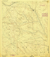
- 1885 Map of Taylor
 1885 Taylor1885 Print · USGSCentral Texas in the late nineteenth century was a landscape in transition as railroads redefined the old cotton frontier. Genealogists and historians can trace the early growth of rail towns like Taylor and Granger, or find vanished rural outposts such as Ad Hall and Davilla.
 - 1885 Map of Bastrop
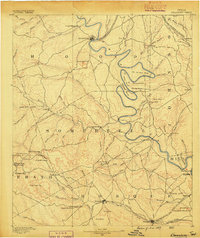
 1885 Bastrop1885 Print · USGSCentral Texas was undergoing a rail-driven transformation in the late nineteenth century as steam power connected the frontier to the Gulf. Genealogists can trace family names and old homesites near Rice's Crossing, Hills Prairie, and along the vital Houston and Texas Central Railroad.
 - 1885 Map of San Saba
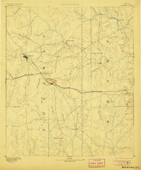
 1885 San Saba1885 Print · USGSCentral Texas in the late nineteenth century comes alive through this survey of the river valleys and high knobs. Genealogists and researchers can trace the early foundations of San Saba and Goldthwaite, or find forgotten locations like Regency and Bendy.
 - 1887 Map of Taylor
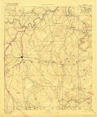
 1887 Taylor1887 Print · USGSCentral Texas is captured in the late nineteenth century as the railroad began to redefine the blackland prairie. Genealogists can locate early settlements like Davilla and Granger or trace family lands near the San Gabriel River and Taylor.
 - 1887 Map of Llano
 1887 Llano1887 Print · USGSThe Texas Hill Country emerges as a frontier of granite peaks and river valleys in the mid-1880s. Researchers can locate early settlements like Castell and Baby Head, or trace the rugged topography of Enchanted Rock and Pack Saddle Mountain.
 - 1887 Map of Lampasas
 1887 Lampasas1887 Print · USGSThe Lampasas region in the late 1880s shows the arrival of the Gulf Colorado and Santa Fe Railroad alongside early frontier settlements. Local historians can trace old post offices and milling sites like Townsen Mills, Wayback, and Senterfitt among the numerous gaps and peaks of the Hill Country.
 - 1887 Map of Blanco
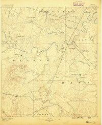 1887 Blanco1887 Print · USGSCentral Texas at the dawn of the Hill Country's development, when early ranching life centered on river fords and spring-fed creeks. Trace the paths between Johnson City, Blanco, and Dripping Springs, or locate landmarks like Jacob's Well and Dead Mans Hole.
 - 1887 Map of Mason
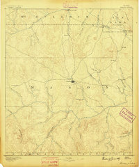 1887 Mason1887 Print · USGSThe Texas Hill Country comes into focus during the late frontier era, centering on the vital cattle and trade crossroads of Mason. Researchers can trace early German-Texan settlements and rural post offices including Loyal Valley, Hoersterville, and Fredonia.
 - 1887 Map of Burnet
 1887 Burnet1887 Print · USGSCentral Texas in the late nineteenth century is defined here by the arrival of the rail line and the wild course of the Colorado River. Genealogists and historians can trace early settlements and transit points like Tiger Mill, Bluffton, and Wolf Crossing.
 - 1887 Map of Coleman, 1889 Print
 1887 Coleman1889 Print · USGSCentral Texas was undergoing a rapid transformation into a rail-connected ranching hub in the late 1880s. Local researchers can trace the early layout of Coleman and locate frontier landmarks like Camp Colorado, Byrds Store, and the Santa Anna Mountains.2 unique versions available
 - 1888 Map of Hamilton
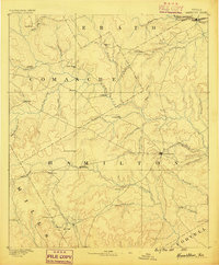 1888 Hamilton1888 Print · USGSCentral Texas during the 1880s is captured here at a moment of early frontier growth and agricultural settlement. Researchers can trace the original locations of rural centers like Gentry Mill, Pottsville, and the remote post office at Indian Gap.
 - 1888 Map of Meridian
 1888 Meridian1888 Print · USGSBosque and Coryell counties are shown here in the 1880s as the rail lines began to redefine the frontier landscape. Genealogists can locate early settlements like Turnersville, Cranfills Gap, and the rail junction at Meridian.
 - 1889 Map of Granbury
 1889 Granbury1889 Print · USGSIn the late 1880s, the Brazos River dictated the life and travel of North Texas, carving deep bends through Hood and Somervell counties. Genealogists and historians can trace early settlements like Fort Spunky and Glenrose or the routes of the Texas Central Railroad.6 unique versions available
 - 1889 Map of Brownwood
 1889 Brownwood1889 Print · USGSCentral Texas ranching and rail expansion are captured here in the late nineteenth century. You can trace early family settlements and landmarks like Williams Ranch, Comanche, and the path of the Gulf Colorado and Santa Fe Railroad.
 - 1889 Map of Coleman, 1905 Print
 1889 Coleman1905 Print · USGSCentral Texas is captured in the late nineteenth century as the railroad began transforming the frontier into a network of cattle and farming towns. Genealogists can trace early homesteading hubs and remote outposts like Camp Colorado, Byrds Store, and Trickham.4 unique versions available
 - 1890 Map of Stephenville
 1890 Stephenville1890 Print · USGSErath County at the close of the frontier era centers on the rising trade hub of Stephenville and its surrounding hill country. Researchers can trace the original Texas Central Railroad corridor through Dublin and find vanished locales like Duffau Wells.5 unique versions available
 - 1890 Map of Breckenridge
 1890 Breckenridge1890 Print · USGSStephens County was a landscape of budding settlements and cattle country in the late nineteenth century. Genealogists can trace early homesteads near Breckenridge or follow the Texas and Pacific R.R. past peaks like Steal Easy Mt. and Gunsight Mt..6 unique versions available
 - 1890 Map of Abilene, 1955 Print
 1890 Abilene1955 Print · USGSWest Texas ranching country and rail settlements come alive in the 1890s as the railroad transforms the prairie. Genealogists can trace early homesteads near Buffalo Gap or follow the Texas and Pacific Railway through Abilene and Elmdale.
 - 1891 Map of Weatherford
 1891 Weatherford1891 Print · USGSParker County and the surrounding ranchlands are shown here in the 1890s as the rail network transformed the region. Researchers can trace early river transport at Powell Ferry or locate vanished sites like Veal Station, Center Mill, and the Bear Creek P.O.
 - 1891 Map of Hayrick
 1891 Hayrick1891 Print · USGSTexas ranching country and the arrival of the iron horse meet in the 1890s as the Colorado River divides emerging frontier counties. Genealogists and historians can trace the early foundations of Hayrick and Rowena, or locate remote landmarks like Harris Ranch and the Rock Spring School House.
 - 1891 Map of Las Cruces
 1891 Las Cruces1891 Print · USGSThe Mesilla Valley and Organ Mountains are shown here during the late territorial era, when the railroad was transforming the region. Genealogists and historians can trace early settlements like Mesilla, Fort Selden, and the mining hub at Organ City.
 - 1891 Map of Dallas
 1891 Dallas1891 Print · USGSThe Dallas area during the late nineteenth century was a rapidly growing rail hub still defined by its river crossings and rural outposts. Genealogists and historians can trace the foundations of the metroplex through early landmarks like Oak Cliff, Doddy's Ferry, and Haughts Store.
 - 1891 Map of Palo Pinto
 1891 Palo Pinto1891 Print · USGSNorth Texas in the late nineteenth century was a landscape of winding river bends and emerging coal towns. Genealogists and historians can trace early river crossings at Oaks Ferry, the path of the Texas and Pacific Railroad, and the Coal Mines at Coalville.7 unique versions available
 - 1891 Map of Anson
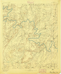
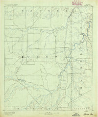 1891 Anson1891 Print · USGSJones County was still a frontier of small settlements and river crossings in the early 1890s. Genealogists and researchers can trace the early footprints of Anson alongside forgotten locales like Sandersville, Phantom Hill, and Rising Sun.
 - 1891 Map of Cleburne
 1891 Cleburne1891 Print · USGSNorth Texas in the late nineteenth century was a land transformed by new iron rails and established river crossings. Genealogists and researchers can trace the early footprints of Cleburne and Hillsboro alongside vanished stops like Port Graham and Files Valley.
Showing maps 1-25
Top cities of Texas
- Houston historical maps
- San Antonio historical maps
- Dallas historical maps
- Fort Worth historical maps
- Austin historical maps
- El Paso historical maps
See more
Top counties of Texas
- Harris County historical maps
- Dallas County historical maps
- Tarrant County historical maps
- Bexar County historical maps
- Travis County historical maps
- Collin County historical maps
See more
Frequently asked questions
- What are the different types of historical maps available for Texas?
- What is the oldest map of Texas?
- Where can I purchase historical maps of Texas for my home or office?
- Where can I download high-res historical maps of Texas?
- Are there historical topographic maps available for Texas?
- Is there historical aerial imagery available for Texas?
- Where are historical maps of Texas sourced from?