1910s Maps of Texas
Explore 189 historic maps of Texas from the 1910s. These maps offer a rare glimpse into what life looked like during the 1910s — showing old roads, neighborhoods, homes, and landmarks that have changed or disappeared over time.
Whether you're researching your family's past, planning a metal detecting trip, or studying how Texas's landscape evolved across the 1910s, these high-resolution maps are a powerful tool for exploring the history of this region.
- Focus on a specific era: All maps on this page are from the 1910s, giving you a focused view of this time period.
- See what’s changed: Compare century-old streets, trails, and buildings to today's modern landscape using overlays and satellite layers.
- Research with precision: Use these maps for genealogy, historical research, land use analysis, or educational projects.
- View, download, or print: Maps are fully viewable online in high resolution, and can be downloaded or printed for your own records.
Start exploring Texas's history through authentic maps from the 1910s. This is your window into the past.
Texas maps
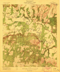
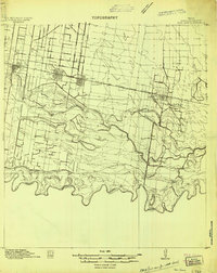
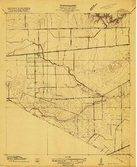
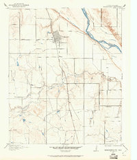
- 1910 Map of Linden
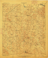 1910 Linden1910 Print · USGSNortheast Texas at the dawn of the century reveals a landscape defined by the timber industry and small rural hubs. You can trace the development of Cass County through landmarks like the T.P. Sawmill, Bryans Mill, and dozens of family-named sites like Harbucks Store.2 unique versions available
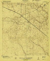
 - 1910 Map of Atlanta
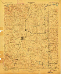 1910 Atlanta1910 Print · USGSNortheast Texas at the height of the timber boom is captured here, showing the intricate network of sawmills and rail lines crossing into Arkansas and Louisiana. Genealogists can locate family landmarks like Laws Chapel, Hosey's Store, and the Henderson Hill School among the many rural settlements.2 unique versions available
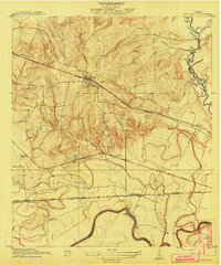
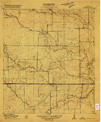
 - 1910 Map of Austin
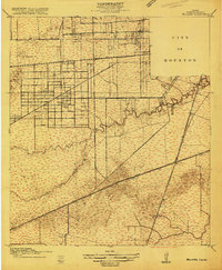
 1910 Austin1910 Print · USGSAustin and the surrounding Travis County hill country are captured here at the start of the twentieth century. Genealogists and researchers can locate pioneer landmarks like Anderson Mill, Mc.Kinney Falls, and numerous river crossings including Lohmann Ford.3 unique versions available
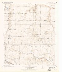
 - 1910 Map of Buckholts, 1911 Print
 1910 Buckholts1911 Print · USGSThe Milam County bottomlands along the Little River appear here just before major levee projects reshaped the valley. Trace family homesteads and crossings like the Live Oak School, Bryant Station Bridge, and Nielson Farm.
 - 1911 Map of San Marcos
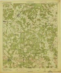
 1911 San Marcos1911 Print · USGSCentral Texas at the peak of the railroad era shows a landscape of small farming communities and country schools. Genealogists can trace family footprints across Comanche Flat or locate long-gone sites like Highpoint School and Bethany Church.2 unique versions available
 - 1912 Map of Rockwall
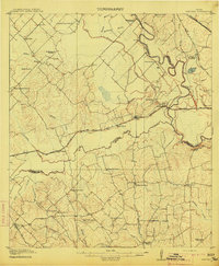
 1912 Rockwall1912 Print · USGSTexas blackland prairie and river bottoms are captured here in the years before the landscape was transformed by suburban expansion. Genealogists can locate family homesites near rural landmarks like Lewis Store, Wards Chapel, and the Elm Grove School.2 unique versions available
 - 1912 Map of Buckholts
 1912 Buckholts1912 Print · USGSMilam County was a landscape of river-bottom farms and rural school districts in the years before the Great War. You can trace early family holdings like Stink Hill Farm and find community landmarks such as Friendship Church and the Wire Bridge.
 - 1913 Map of Millican
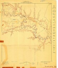
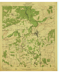
 1913 Millican1913 Print · USGSBrazos County at the beginning of the twentieth century was a critical rail junction defined by large-scale valley farming and the winding river border. Researchers can trace historic riverfront operations and rail stops including Millican, Hidalgo Falls, and the Steele Farm.3 unique versions available
 - 1914 Map of Daingerfield
 1914 Daingerfield1914 Print · USGSNortheast Texas before the Great War is captured here through its bustling rail towns and timber-rich creek bottoms. Genealogists can trace hundreds of family sites, from Walkers Chapel and Boon Hall to the busy Jennings Lake Switch.2 unique versions available
 - 1914 Map of Gay Hill
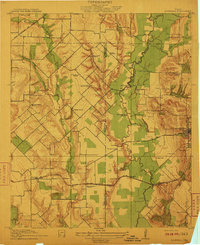
 1914 Gay Hill1914 Print · USGSThe Brazos River valley in the early twentieth century shows a thriving rail-and-farm economy across three counties. Genealogists can trace family landmarks and rural school sites like Wiedes Store, Old Gay Hill, and the Allseeing Eye School.2 unique versions available
 - 1914 Map of San Juan
 1914 San Juan1914 Print · USGSThe Lower Rio Grande Valley is captured here just before the First World War, showing the early rail-driven growth of McAllen, Pharr, and San Juan. Genealogists and historians can trace the transition from old river-side life along the Military Road to the irrigation-based settlements at Ebenezer and Valley View Plantation.2 unique versions available
 - 1914 Map of Navasota
 1914 Navasota1914 Print · USGSBefore the modernization of the Brazos valley, this 1910s era survey captures the thriving rail-and-river economy of Grimes and Washington counties. Genealogists can trace early homesteads and community hubs like Wilsons Gin, Prairie Church, and Grange Hall School.2 unique versions available
 - 1915 Map of Bellaire
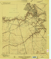
 1915 Bellaire1915 Print · USGSThe Harris County prairie southwest of Houston comes alive in this mid-1910s survey of emerging suburban and rural life. Genealogists and historians can trace the early footprints of Bellaire, the Rice Institute, and long-forgotten sites like the Poor Farm or Girls Industrial School.2 unique versions available
 - 1915 Map of Park Place
 1915 Park Place1915 Print · USGSSoutheast Houston and the thriving ship channel districts are captured here just before the first World War. Genealogists and industrial historians can trace the early residential blocks of Magnolia and Park Place or the rail yards at South Yards.2 unique versions available
 - 1915 Map of Houston Heights
 1915 Houston Heights1915 Print · USGSThe outskirts of Houston are just beginning to take their modern shape in the mid-1910s as new residential grids emerge along the bayous. Genealogists and historians can trace early neighborhood boundaries in Independence Heights and locate vanished rural landmarks like Hohl School and Rosslyn.2 unique versions available
 - 1915 Map of Alief
 1915 Alief1915 Print · USGSIn the years before Houston's westward sprawl, this prairie landscape was a remote network of dairy farms and rail lines. You can trace the early foundations of these communities at Alief, Traceyville Church, and along the rural paths of Westheimer Road.3 unique versions available
 - 1915 Map of Cypress
 1915 Cypress1915 Print · USGSCoastal prairie and creek-side settlements define this Harris County area during the early twentieth century. Researchers can trace historic landholdings like Bains Ranch or find early educational sites including Big Cypress School and Brink School.3 unique versions available
 - 1915 Map of Deepwater
 1915 Deepwater1915 Print · USGSSoutheast of Houston during the early twentieth-century boom, this area shows the vital transformation of the coastal prairie into an industrial hub. Trace the early footprints of Pasadena, South Houston, and Genoa alongside the Ship Channel and the Penn City School.
 - 1915 Map of Katy
 1915 Katy1915 Print · USGSKaty was a budding rail settlement on the Texas prairie during the early twentieth century. Genealogists and local historians can trace the early town site along the Missouri Kansas and Texas tracks and locate the South Mayde School.3 unique versions available
 - 1915 Map of Addicks
 1915 Addicks1915 Print · USGSWestern Harris County was a region of prairie farmsteads and vital rail connections during the mid-1910s. Genealogists can trace early homesteads like the Gertie Rice Farm or locate community centers such as the German Methodist Church and Barker School.3 unique versions available
 - 1915 Map of Hillendahl
 1915 Hillendahl1915 Print · USGSHarris County west of Houston is captured here during the mid-1910s, showing a rural landscape of schools, creeks, and early rail lines. Genealogists can trace the early community around Hillendahl School and the tracks of the Houston and Texas Central.3 unique versions available
 - 1915 Map of Clodine, 1961 Print
 1915 Clodine1961 Print · USGSSoutheast Texas prairie life is captured here during the mid-teens, when rail lines dictated the growth of small settlements. Trace the early footprints of Clodine and Howell or locate the defunct route of the Texas Western R R (Abandoned).
 - 1915 Map of Clara, 1961 Print
 1915 Clara1961 Print · USGSWichita County was a land of rural schoolhouses and river crossings during the early twentieth century. Researchers can trace the original locations of Fairview School, Wyeth School, and the settlement of Clara along the banks of the Red River.
 - 1915 Map of Barwise School, 1961 Print
 1915 Barwise School1961 Print · USGSWichita County was a landscape of remote school districts and winding prairie creeks during the early years of the twentieth century. Researchers can trace the rural infrastructure of the era through landmarks like Barwise School, the Fort Worth and Denver City rail line, and Tenth Cavalry Creek.
 - 1915 Map of Burkburnett, 1961 Print
 1915 Burkburnett1961 Print · USGSThe Texas-Oklahoma borderlands south of the Red River are shown here in the mid-1910s as rail and road networks began to reshape the frontier. Researchers can trace the early layout of Burkburnett, the location of the Cashion School, and the route of the Wichita Falls and Northwestern railroad.
Showing maps 1-25
Top cities of Texas
- Houston historical maps
- San Antonio historical maps
- Dallas historical maps
- Fort Worth historical maps
- Austin historical maps
- El Paso historical maps
See more
Top counties of Texas
- Harris County historical maps
- Dallas County historical maps
- Tarrant County historical maps
- Bexar County historical maps
- Travis County historical maps
- Collin County historical maps
See more
Frequently asked questions
- What are the different types of historical maps available for Texas?
- What is the oldest map of Texas?
- Where can I purchase historical maps of Texas for my home or office?
- Where can I download high-res historical maps of Texas?
- Are there historical topographic maps available for Texas?
- Is there historical aerial imagery available for Texas?
- Where are historical maps of Texas sourced from?