
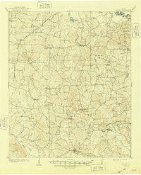
1910 Map of Linden
USGS Topo · Published 1910About this map
The county seat of Linden anchors the southern edge of this survey, serving as a hub for the early twentieth-century timber and farming communities of Cass County. The terrain is defined by the Cusseta Mts and Texas Mts, which rise above a network of drainages including Overcup Creek and Fraxier Creek that flow toward the Sulphur River at the northern boundary. This era in East Texas history is visible through the concentration of decentralized rural infrastructure, such as the T.P. Sawmill and numerous neighborhood centers like Douglassville and Cusseta. Genealogists will find a high density of country schools and churches, including O'Farrell School, New Hope School, and Corinth Church, alongside early transportation routes like the North East Texas Road and several segments of Tram Road, reflecting a landscape deeply tied to the lumber industry.
Find a feature on this map
60 named features on this map. Tap any name to fly to it.
Don’t see what you’re looking for? This feature index may not catch every label — zoom into the map to look around manually.
Map Details
Editions of this 1910 Linden Map
2 editions found
Other maps of this area

1907 · Atlanta
USGS Topo · 1:62,500

1909 · New Boston
USGS Topo · 1:62,500

1909 · Texarkana
USGS Topo · 1:62,500

1910 · Atlanta
USGS Topo · 1:62,500

1914 · Daingerfield
USGS Topo · 1:62,500

1930 · Bassett
USGS Topo · 1:62,500

1944 · Kildare
USGS Topo · 1:62,500

1948 · Kildare
USGS Topo · 1:62,500

1953 · Texarkana
USGS Topo · 1:250,000

1954 · Lake Texarkana
USGS Topo · 1:24,000