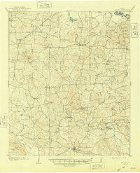
1910 Map of Linden
USGS Topo · Published 1948About this map
The Cusseta Mts dominate the central landscape of Cass County in this survey conducted shortly after the turn of the century. The county seat of Linden serves as the primary hub in the south, while the northern boundary is defined by the winding course of the Sulphur River and Knights Bluff. The local economy of the era is clearly visible through industrial markers like the T.P. Sawmill and the network of logging routes including the Probans Tramroad.
Find a feature on this map
64 named features on this map. Tap any name to fly to it.
Don’t see what you’re looking for? This feature index may not catch every label — zoom into the map to look around manually.
Map Details
Editions of this 1910 Linden Map
2 editions found
Other maps of this area

1907 · Atlanta
USGS Topo · 1:62,500

1909 · New Boston
USGS Topo · 1:62,500

1909 · Texarkana
USGS Topo · 1:62,500

1910 · Linden
USGS Topo · 1:62,500

1910 · Atlanta
USGS Topo · 1:62,500

1914 · Daingerfield
USGS Topo · 1:62,500

1930 · Bassett
USGS Topo · 1:62,500

1944 · Kildare
USGS Topo · 1:62,500

1948 · Kildare
USGS Topo · 1:62,500

1953 · Texarkana
USGS Topo · 1:250,000