Old Maps of High Point at The Villages of Westcreek, Bexar County for Academic Research
Study the evolution of High Point at The Villages of Westcreek with 6 high-resolution historic maps. Whether you're teaching, researching, or modeling changes in land use, these maps provide essential visual documentation of urban, environmental, and geographic change.
- Analyze long-term change: Track patterns in development, transportation, and natural features.
- Ideal for environmental or urban studies: Support academic projects with primary historical map data.
- Use in the classroom or lab: Educators and researchers rely on these maps to bring historical context to life.
These maps are a powerful tool for teaching, research, and visualizing how High Point at The Villages of Westcreek has changed over the decades.
High Point at The Villages of Westcreek, Bexar County maps
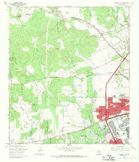
(6)- 1953 Map of Culebra Hill, 1959 Print
 1953 Culebra Hill1959 Print · USGSCovers High Point at The Villages of Westcreek, including San Antonio, Leon Valley, and other nearby areas
 - 1954 Map of San Antonio, 1964 Print
 1954 San Antonio1964 Print · USGSCovers High Point at The Villages of Westcreek, including San Antonio, New Braunfels, and other nearby areas3 unique versions available
 - 1957 Map of San Antonio
 1957 San Antonio1957 Print · USGSCovers High Point at The Villages of Westcreek, including San Antonio, New Braunfels, and other nearby areas
 - 1966 Map of Culebra Hill, 1969 Print
 1966 Culebra Hill1969 Print · USGSCovers High Point at The Villages of Westcreek, including San Antonio, Leon Valley, and other nearby areas3 unique versions available
 - 1985 Map of San Antonio
 1985 San Antonio1985 Print · USGSCovers High Point at The Villages of Westcreek, including San Antonio, Schertz, and other nearby areas3 unique versions available
 - 1993 Map of Culebra Hill
 1993 Culebra Hill1993 Print · USGSCovers High Point at The Villages of Westcreek, including San Antonio, Leon Valley, and other nearby areas2 unique versions available
End of results
Showing maps 1-6 of 6
Frequently asked questions
- What are the different types of historical maps available for High Point at The Villages of Westcreek?
- What is the oldest map of High Point at The Villages of Westcreek?
- Where can I purchase historical maps of High Point at The Villages of Westcreek for my home or office?
- Where can I download high-res historical maps of High Point at The Villages of Westcreek?
- Are there historical topographic maps available for High Point at The Villages of Westcreek?
- Is there historical aerial imagery available for High Point at The Villages of Westcreek?
- Where are historical maps of High Point at The Villages of Westcreek sourced from?