1980s Maps of Beatty Place, Texas
Explore 2 historic maps of Beatty Place from the 1980s. These maps offer a rare glimpse into what life looked like during the 1980s — showing old roads, neighborhoods, homes, and landmarks that have changed or disappeared over time.
Whether you're researching your family's past, planning a metal detecting trip, or studying how Beatty Place's landscape evolved across the 1980s, these high-resolution maps are a powerful tool for exploring the history of this region.
- Focus on a specific era: All maps on this page are from the 1980s, giving you a focused view of this time period.
- See what’s changed: Compare century-old streets, trails, and buildings to today's modern landscape using overlays and satellite layers.
- Research with precision: Use these maps for genealogy, historical research, land use analysis, or educational projects.
- View, download, or print: Maps are fully viewable online in high resolution, and can be downloaded or printed for your own records.
Start exploring Beatty Place's history through authentic maps from the 1980s. This is your window into the past.
Beatty Place, TX maps
(2)- 1983 Map of Gilliland Peak, 1984 Print
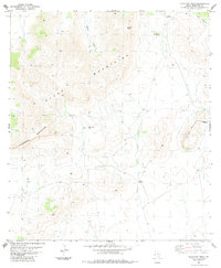 1983 Gilliland Peak1984 Print · USGSThe Trans-Pecos ranchlands of the early eighties are mapped here in detail, showing a sparse landscape dominated by the high ridges of the Glass Mountains. Researchers can trace old family footprints at Iron Mountain Ranch or locate isolated markers like the Cem and a lone Grave.
 - 1985 Map of Alpine
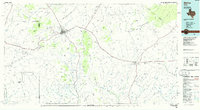 1985 Alpine1985 Print · USGSWest Texas ranching and rail life are documented here in the mid-1980s as the region centers on Alpine. Trace the iron paths of the Southern Pacific and Atchison Topeka and Santa Fe through settlements like Marathon and Altuda.2 unique versions available
End of results
Showing maps 1-2 of 2
Top cities near Beatty Place
Frequently asked questions
- What are the different types of historical maps available for Beatty Place?
- What is the oldest map of Beatty Place?
- Where can I purchase historical maps of Beatty Place for my home or office?
- Where can I download high-res historical maps of Beatty Place?
- Are there historical topographic maps available for Beatty Place?
- Is there historical aerial imagery available for Beatty Place?
- Where are historical maps of Beatty Place sourced from?