1900s (20th Century) Maps of Corner Windmill, Texas
Explore 8 historic maps of Corner Windmill from the 1900s (20th Century). These maps offer a rare glimpse into what life looked like during the 1900s — showing old roads, neighborhoods, homes, and landmarks that have changed or disappeared over time.
Whether you're researching your family's past, planning a metal detecting trip, or studying how Corner Windmill's landscape evolved across the 1900s, these high-resolution maps are a powerful tool for exploring the history of this region.
- Focus on a specific era: All maps on this page are from the 1900s, giving you a focused view of this time period.
- See what’s changed: Compare century-old streets, trails, and buildings to today's modern landscape using overlays and satellite layers.
- Research with precision: Use these maps for genealogy, historical research, land use analysis, or educational projects.
- View, download, or print: Maps are fully viewable online in high resolution, and can be downloaded or printed for your own records.
Start exploring Corner Windmill's history through authentic maps from the 1900s. This is your window into the past.
Corner Windmill, TX maps
(8)- 1917 Map of Bone Spring, 1957 Print
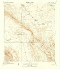 1917 Bone Spring1957 Print · USGSThe Brewster County ranching frontier is captured here in the years following the first World War. Researchers can trace the early road network and family outposts like Hendersons Ranch, the Old Wax Plant, and the vital waters of Bone Spring.
 - 1918 Map of Bone Spring
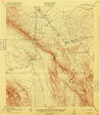 1918 Bone Spring1918 Print · USGSBrewster County ranching outposts and desert industries are captured in high detail just before the close of the Great War. Genealogists and historians can trace family landholdings and early commercial sites like Hendersons Ranch, Stillwell, and the Old Wax Plant.
 - 1918 Map of Bone Spring
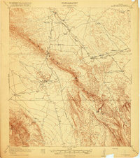 1918 Bone Spring1918 Print · USGSBrewster County was a land of remote ranches and vital desert springs during the years of the Great War. Genealogists and historians can trace the early road network connecting Greene Ranch, the Old Wax Plant, and the namesake Bone Spring.3 unique versions available
 - 1920 Map of Bone Spring
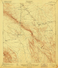 1920 Bone Spring1920 Print · USGSBrewster County's high-desert frontier is captured in the years following the Great War, showing a landscape defined by isolated ranching outposts and rugged mountain gaps. Genealogists and historians can trace family landholdings and early industry through sites like Walkers Ranch, Buttrell Ranch, and the Old Wax Plant.2 unique versions available
 - 1959 Map of Emory Peak, 1967 Print
 1959 Emory Peak1967 Print · USGSThe Big Bend country of West Texas is documented here just as the national park was becoming a major destination. Researchers can trace remote desert outposts like Lajitas, Castolon, and the Terlingua Post Office along the winding Rio Grande.3 unique versions available
 - 1965 Map of Emory Peak
 1965 Emory Peak1965 Print · USGSThe Big Bend backcountry in the mid-1960s reveals a desert landscape of remote ranches and mercury mining. Trace the historic boundary along the Rio Grande and locate landmarks like the Fresno Mine and Panther Spring.
 - 1971 Map of Bone Spring NE, 1974 Print
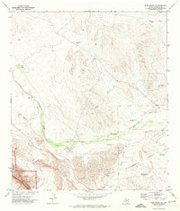 1971 Bone Spring NE1974 Print · USGSBrewster County ranching and conservation lands come into focus in the early seventies as the desert landscape meets the high peaks. Trace remote water sources and family names at Cow Heaven Tank, Gooden Windmill, and Shackleford Well.2 unique versions available
 - 1985 Map of Santiago Mountains, 1994 Print
 1985 Santiago Mountains1994 Print · USGSThe Trans-Pecos region of West Texas in the mid-1980s reveals a vast network of isolated ranching outposts and protected wildlands. Genealogists and historians can trace old homesteads near Butcherknife and Cochran or locate landmarks like Santiago Peak and Nine Point Mesa.2 unique versions available
End of results
Showing maps 1-8 of 8
Frequently asked questions
- What are the different types of historical maps available for Corner Windmill?
- What is the oldest map of Corner Windmill?
- Where can I purchase historical maps of Corner Windmill for my home or office?
- Where can I download high-res historical maps of Corner Windmill?
- Are there historical topographic maps available for Corner Windmill?
- Is there historical aerial imagery available for Corner Windmill?
- Where are historical maps of Corner Windmill sourced from?