1920s Maps of Crane, Texas
Explore 1 historic maps of Crane from the 1920s. These maps offer a rare glimpse into what life looked like during the 1920s — showing old roads, neighborhoods, homes, and landmarks that have changed or disappeared over time.
Whether you're researching your family's past, planning a metal detecting trip, or studying how Crane's landscape evolved across the 1920s, these high-resolution maps are a powerful tool for exploring the history of this region.
- Focus on a specific era: All maps on this page are from the 1920s, giving you a focused view of this time period.
- See what’s changed: Compare century-old streets, trails, and buildings to today's modern landscape using overlays and satellite layers.
- Research with precision: Use these maps for genealogy, historical research, land use analysis, or educational projects.
- View, download, or print: Maps are fully viewable online in high resolution, and can be downloaded or printed for your own records.
Start exploring Crane's history through authentic maps from the 1920s. This is your window into the past.
Crane, TX maps
(1)- 1928 Map of Crane
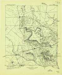 1928 Crane1928 Print · USGSWest Texas ranching and the early oil boom meet at the Pecos River during the late twenties. Trace the growth of new petroleum hubs at Crane and McCamey alongside family-named landmarks like McElroy and Cody Bell.
End of results
Showing maps 1-1 of 1
Top neighborhoods of Crane
- Sandy Acres historical maps
- Atreco Addition historical maps
- Bosmans Addition historical maps
- Castle Gap historical maps
- Hillside Addition historical maps
- Hollins Addition historical maps
See more
Frequently asked questions
- What are the different types of historical maps available for Crane?
- What is the oldest map of Crane?
- Where can I purchase historical maps of Crane for my home or office?
- Where can I download high-res historical maps of Crane?
- Are there historical topographic maps available for Crane?
- Is there historical aerial imagery available for Crane?
- Where are historical maps of Crane sourced from?