1900s (20th Century) Maps of Kincheloe Subdivision, Crane County
Explore 5 historic maps of Kincheloe Subdivision from the 1900s (20th Century). These maps offer a rare glimpse into what life looked like during the 1900s — showing old roads, neighborhoods, homes, and landmarks that have changed or disappeared over time.
Whether you're researching your family's past, planning a metal detecting trip, or studying how Kincheloe Subdivision's landscape evolved across the 1900s, these high-resolution maps are a powerful tool for exploring the history of this region.
- Focus on a specific era: All maps on this page are from the 1900s, giving you a focused view of this time period.
- See what’s changed: Compare century-old streets, trails, and buildings to today's modern landscape using overlays and satellite layers.
- Research with precision: Use these maps for genealogy, historical research, land use analysis, or educational projects.
- View, download, or print: Maps are fully viewable online in high resolution, and can be downloaded or printed for your own records.
Start exploring Kincheloe Subdivision's history through authentic maps from the 1900s. This is your window into the past.
Kincheloe Subdivision, Crane County maps
(5)- 1928 Map of Crane
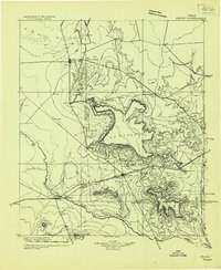 1928 Crane1928 Print · USGSWest Texas ranching and the early oil boom meet at the Pecos River during the late twenties. Trace the growth of new petroleum hubs at Crane and McCamey alongside family-named landmarks like McElroy and Cody Bell.
 - 1954 Map of Pecos, 1964 Print
 1954 Pecos1964 Print · USGSMid-century West Texas reveals a landscape of expanding oil fields and cattle ranching along the winding Pecos River. Local historians can trace family ranch lands like Goodrich Ranch, follow the Texas and Pacific rails, or locate the historic Horsehead Crossing.3 unique versions available
 - 1957 Map of Pecos
 1957 Pecos1957 Print · USGSWest Texas in the mid-fifties is a landscape of desert oil fields and vital rail corridors. Researchers can trace the sprawling Pyote Air Force Base, the historic Horsehead Crossing, and the rail stops at Mentone and Saragosa.
 - 1974 Map of Castle Gap, 1977 Print
 1974 Castle Gap1977 Print · USGSThe Permian Basin landscape near the Crane and Upton County border in the mid-seventies is defined by industrial energy and historic passes. Trace the famous Castle Gap near King Mountain and find local landmarks like County South Cem.
 - 1986 Map of Crane
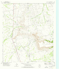
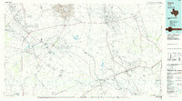 1986 Crane1986 Print · USGSThe Permian Basin oil economy is on full display in the mid-eighties, showing a landscape defined by massive production fields and small company towns. Researchers can trace the infrastructure of the Mc Elroy Oil Field and Abell Oil and Gas Field or locate landmarks like Castle Mountain and Juan Cordona Lake.3 unique versions available
End of results
Showing maps 1-5 of 5
Frequently asked questions
- What are the different types of historical maps available for Kincheloe Subdivision?
- What is the oldest map of Kincheloe Subdivision?
- Where can I purchase historical maps of Kincheloe Subdivision for my home or office?
- Where can I download high-res historical maps of Kincheloe Subdivision?
- Are there historical topographic maps available for Kincheloe Subdivision?
- Is there historical aerial imagery available for Kincheloe Subdivision?
- Where are historical maps of Kincheloe Subdivision sourced from?