1970s Maps of Hereford, Texas
Explore 2 historic maps of Hereford from the 1970s. These maps offer a rare glimpse into what life looked like during the 1970s — showing old roads, neighborhoods, homes, and landmarks that have changed or disappeared over time.
Whether you're researching your family's past, planning a metal detecting trip, or studying how Hereford's landscape evolved across the 1970s, these high-resolution maps are a powerful tool for exploring the history of this region.
- Focus on a specific era: All maps on this page are from the 1970s, giving you a focused view of this time period.
- See what’s changed: Compare century-old streets, trails, and buildings to today's modern landscape using overlays and satellite layers.
- Research with precision: Use these maps for genealogy, historical research, land use analysis, or educational projects.
- View, download, or print: Maps are fully viewable online in high resolution, and can be downloaded or printed for your own records.
Start exploring Hereford's history through authentic maps from the 1970s. This is your window into the past.
Hereford, TX maps
(2)- 1970 Map of Hereford, 1974 Print
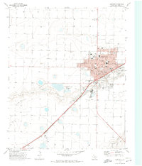 1970 Hereford1974 Print · USGSThe Texas Panhandle cattle and rail hub of Hereford is captured in the early seventies, showcasing a thriving agricultural center. Researchers can trace local lineage through the Rest Lawn Cem, the Courthouse, and community landmarks like St Anthony Sch.
 - 1971 Map of Hereford SE, 1973 Print
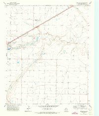 1971 Hereford SE1973 Print · USGSDeaf Smith County comes into focus in the early seventies, showcasing the industrial and aviation growth at the edge of the high plains. Researchers can trace the path of the Atchison Topeka and Santa Fe railroad and locate landmarks like the Hereford Municipal Airport and Salt Evaporators.
End of results
Showing maps 1-2 of 2
Frequently asked questions
- What are the different types of historical maps available for Hereford?
- What is the oldest map of Hereford?
- Where can I purchase historical maps of Hereford for my home or office?
- Where can I download high-res historical maps of Hereford?
- Are there historical topographic maps available for Hereford?
- Is there historical aerial imagery available for Hereford?
- Where are historical maps of Hereford sourced from?