1960s Maps of Arneckeville, Texas
Explore 2 historic maps of Arneckeville from the 1960s. These maps offer a rare glimpse into what life looked like during the 1960s — showing old roads, neighborhoods, homes, and landmarks that have changed or disappeared over time.
Whether you're researching your family's past, planning a metal detecting trip, or studying how Arneckeville's landscape evolved across the 1960s, these high-resolution maps are a powerful tool for exploring the history of this region.
- Focus on a specific era: All maps on this page are from the 1960s, giving you a focused view of this time period.
- See what’s changed: Compare century-old streets, trails, and buildings to today's modern landscape using overlays and satellite layers.
- Research with precision: Use these maps for genealogy, historical research, land use analysis, or educational projects.
- View, download, or print: Maps are fully viewable online in high resolution, and can be downloaded or printed for your own records.
Start exploring Arneckeville's history through authentic maps from the 1960s. This is your window into the past.
Arneckeville, TX maps
(2)- 1960 Map of Beeville
 1960 Beeville1960 Print · USGSCoastal Texas in the mid-fifties reveals a landscape of growing towns and vital military outposts like Foster AFB. Researchers can trace old rail lines including the Missouri Pacific and explore the vast Aransas National Wildlife Refuge.
 - 1963 Map of Meyersville, 1965 Print
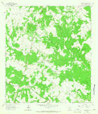 1963 Meyersville1965 Print · USGSMeyersville and Arneckeville appear at a peak of energy production in the early sixties, as gas fields began to overlay the older ranching landscape. Researchers can trace family sites at St Peter and Pauls Ch, the De Witt Sch, and St Joseph Cem.2 unique versions available
End of results
Showing maps 1-2 of 2
Top cities near Arneckeville
Frequently asked questions
- What are the different types of historical maps available for Arneckeville?
- What is the oldest map of Arneckeville?
- Where can I purchase historical maps of Arneckeville for my home or office?
- Where can I download high-res historical maps of Arneckeville?
- Are there historical topographic maps available for Arneckeville?
- Is there historical aerial imagery available for Arneckeville?
- Where are historical maps of Arneckeville sourced from?