1900s (20th Century) Maps of San Jose, Texas
Explore 4 historic maps of San Jose from the 1900s (20th Century). These maps offer a rare glimpse into what life looked like during the 1900s — showing old roads, neighborhoods, homes, and landmarks that have changed or disappeared over time.
Whether you're researching your family's past, planning a metal detecting trip, or studying how San Jose's landscape evolved across the 1900s, these high-resolution maps are a powerful tool for exploring the history of this region.
- Focus on a specific era: All maps on this page are from the 1900s, giving you a focused view of this time period.
- See what’s changed: Compare century-old streets, trails, and buildings to today's modern landscape using overlays and satellite layers.
- Research with precision: Use these maps for genealogy, historical research, land use analysis, or educational projects.
- View, download, or print: Maps are fully viewable online in high resolution, and can be downloaded or printed for your own records.
Start exploring San Jose's history through authentic maps from the 1900s. This is your window into the past.
San Jose, TX maps
(4)- 1956 Map of Benavides
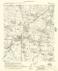 1956 Benavides1956 Print · USGSCoastal plains ranching and the arrival of the oil industry define this South Texas landscape in the early twentieth century. Genealogists can trace family heritage through numerous named homesteads like Hoffman Ranch and Stein Ranch or the tracks of the Texas Mexican R. R.
 - 1956 Map of Laredo, 1960 Print
 1956 Laredo1960 Print · USGSSouth Texas in the mid-fifties reveals a landscape shaped by border commerce, military aviation, and a booming oil industry. Trace the historic Texas and Mexican RR line through Hebbronville or locate the sprawling Mirando City Oil Field and Laredo AFB.3 unique versions available
 - 1968 Map of San Jose, 1971 Print
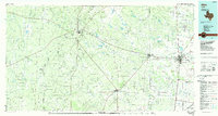
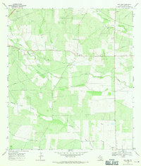 1968 San Jose1971 Print · USGSDuval County ranch lands and early petroleum developments are captured here in the late sixties. Genealogists can trace family heritage through numerous burial sites like Bazan Cem and Garcia Cem or locate the rural communities of San Jose and Olmos.
 - 1985 Map of Alice
 1985 Alice1985 Print · USGSSouth Texas in the mid-eighties was a landscape defined by extensive petroleum development and vital rail corridors. Trace the growth of Alice and San Diego alongside industrial landmarks like the Seven Sisters Oil Field and the Texas Mexican line.2 unique versions available
End of results
Showing maps 1-4 of 4
Top cities near San Jose
- Alice historical maps
- San Diego historical maps
- Premont historical maps
- Ben Bolt historical maps
- Benavides historical maps
Frequently asked questions
- What are the different types of historical maps available for San Jose?
- What is the oldest map of San Jose?
- Where can I purchase historical maps of San Jose for my home or office?
- Where can I download high-res historical maps of San Jose?
- Are there historical topographic maps available for San Jose?
- Is there historical aerial imagery available for San Jose?
- Where are historical maps of San Jose sourced from?