1960s Maps of Lockney, Texas
Explore 2 historic maps of Lockney from the 1960s. These maps offer a rare glimpse into what life looked like during the 1960s — showing old roads, neighborhoods, homes, and landmarks that have changed or disappeared over time.
Whether you're researching your family's past, planning a metal detecting trip, or studying how Lockney's landscape evolved across the 1960s, these high-resolution maps are a powerful tool for exploring the history of this region.
- Focus on a specific era: All maps on this page are from the 1960s, giving you a focused view of this time period.
- See what’s changed: Compare century-old streets, trails, and buildings to today's modern landscape using overlays and satellite layers.
- Research with precision: Use these maps for genealogy, historical research, land use analysis, or educational projects.
- View, download, or print: Maps are fully viewable online in high resolution, and can be downloaded or printed for your own records.
Start exploring Lockney's history through authentic maps from the 1960s. This is your window into the past.
Lockney, TX maps
(2)- 1965 Map of Lockney, 1968 Print
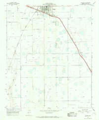 1965 Lockney1968 Print · USGSLockney and the surrounding Floyd County plains are captured in the mid-1960s, showing a landscape defined by industrial agriculture and competing railroads. Genealogists can trace the rail sidings of the Fort Worth and Denver or locate the Fairground and Muncy station.
 - 1966 Map of Sterley, 1967 Print
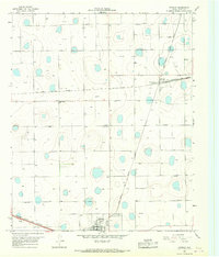 1966 Sterley1967 Print · USGSFloyd County at the height of the mid-century agricultural era shows a landscape shaped by the intersection of two vital railroads. Genealogists and historians can locate the Prairie Chapel Sch, a local Cemetery, and the rail-side industrial activity of Lockney.
End of results
Showing maps 1-2 of 2
Top cities near Lockney
Frequently asked questions
- What are the different types of historical maps available for Lockney?
- What is the oldest map of Lockney?
- Where can I purchase historical maps of Lockney for my home or office?
- Where can I download high-res historical maps of Lockney?
- Are there historical topographic maps available for Lockney?
- Is there historical aerial imagery available for Lockney?
- Where are historical maps of Lockney sourced from?