1970s Maps of Cinco Ranch, Fort Bend County
Explore 4 historic maps of Cinco Ranch from the 1970s. These maps offer a rare glimpse into what life looked like during the 1970s — showing old roads, neighborhoods, homes, and landmarks that have changed or disappeared over time.
Whether you're researching your family's past, planning a metal detecting trip, or studying how Cinco Ranch's landscape evolved across the 1970s, these high-resolution maps are a powerful tool for exploring the history of this region.
- Focus on a specific era: All maps on this page are from the 1970s, giving you a focused view of this time period.
- See what’s changed: Compare century-old streets, trails, and buildings to today's modern landscape using overlays and satellite layers.
- Research with precision: Use these maps for genealogy, historical research, land use analysis, or educational projects.
- View, download, or print: Maps are fully viewable online in high resolution, and can be downloaded or printed for your own records.
Start exploring Cinco Ranch's history through authentic maps from the 1970s. This is your window into the past.
Cinco Ranch, Fort Bend County maps
(4)- 1970 Map of Clodine, 1973 Print
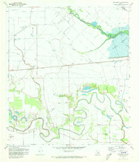
 1970 Clodine1973 Print · USGSFort Bend County in the early seventies shows a landscape of institutional farms and early suburban edges. Genealogists and researchers can trace the roads around Clodine, the grounds of the State Prison Farm, and local landmarks like Hull Field.
 - 1971 Map of Richmond NE, 1973 Print
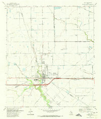
 1971 Richmond NE1973 Print · USGSFort Bend and Harris counties are captured in the early seventies, showcasing a rural landscape defined by creek meanders and early energy development. Genealogists can locate Goss Cem and Briscoe Cem or trace family sites near Foster and Gaston.3 unique versions available
 - 1971 Map of Katy, 1974 Print
 1971 Katy1974 Print · USGSThe town of Katy and its surrounding oil fields are documented here in the early 1970s, showing a prairie landscape transitioning into an industrial and suburban hub. Genealogists and local historians can locate Magnolia Cem, Beckendorf, and the Odessa Kilpatrick Sch along the Missouri Kansas Texas rail line.3 unique versions available
 - 1975 Map of Houston, 1977 Print
 1975 Houston1977 Print · USGSThe Texas Gulf Coast in the mid-seventies shows a sprawling Houston metropolis linked to the sea by the massive Houston Ship Channel. Researchers can trace the mid-century industrial landscape from the Astrodome to the Lyndon B. Johnson Space Center.2 unique versions available
End of results
Showing maps 1-4 of 4
Frequently asked questions
- What are the different types of historical maps available for Cinco Ranch?
- What is the oldest map of Cinco Ranch?
- Where can I purchase historical maps of Cinco Ranch for my home or office?
- Where can I download high-res historical maps of Cinco Ranch?
- Are there historical topographic maps available for Cinco Ranch?
- Is there historical aerial imagery available for Cinco Ranch?
- Where are historical maps of Cinco Ranch sourced from?