1960s Maps of Goliad, Texas
Explore 2 historic maps of Goliad from the 1960s. These maps offer a rare glimpse into what life looked like during the 1960s — showing old roads, neighborhoods, homes, and landmarks that have changed or disappeared over time.
Whether you're researching your family's past, planning a metal detecting trip, or studying how Goliad's landscape evolved across the 1960s, these high-resolution maps are a powerful tool for exploring the history of this region.
- Focus on a specific era: All maps on this page are from the 1960s, giving you a focused view of this time period.
- See what’s changed: Compare century-old streets, trails, and buildings to today's modern landscape using overlays and satellite layers.
- Research with precision: Use these maps for genealogy, historical research, land use analysis, or educational projects.
- View, download, or print: Maps are fully viewable online in high resolution, and can be downloaded or printed for your own records.
Start exploring Goliad's history through authentic maps from the 1960s. This is your window into the past.
Goliad, TX maps
(2)- 1960 Map of Beeville
 1960 Beeville1960 Print · USGSCoastal Texas in the mid-fifties reveals a landscape of growing towns and vital military outposts like Foster AFB. Researchers can trace old rail lines including the Missouri Pacific and explore the vast Aransas National Wildlife Refuge.
 - 1962 Map of Goliad, 1964 Print
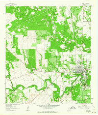 1962 Goliad1964 Print · USGSGoliad sits at a historic crossroads in the early sixties, where colonial Spanish ruins meet the mid-century river economy. Researchers can trace ancestral sites like Glendale Cem and the grounds of Presidio La Bahia (Ruins).3 unique versions available
End of results
Showing maps 1-2 of 2
Frequently asked questions
- What are the different types of historical maps available for Goliad?
- What is the oldest map of Goliad?
- Where can I purchase historical maps of Goliad for my home or office?
- Where can I download high-res historical maps of Goliad?
- Are there historical topographic maps available for Goliad?
- Is there historical aerial imagery available for Goliad?
- Where are historical maps of Goliad sourced from?