1900s (20th Century) Maps of Lakewood Heights, Houston
Explore 7 historic maps of Lakewood Heights from the 1900s (20th Century). These maps offer a rare glimpse into what life looked like during the 1900s — showing old roads, neighborhoods, homes, and landmarks that have changed or disappeared over time.
Whether you're researching your family's past, planning a metal detecting trip, or studying how Lakewood Heights's landscape evolved across the 1900s, these high-resolution maps are a powerful tool for exploring the history of this region.
- Focus on a specific era: All maps on this page are from the 1900s, giving you a focused view of this time period.
- See what’s changed: Compare century-old streets, trails, and buildings to today's modern landscape using overlays and satellite layers.
- Research with precision: Use these maps for genealogy, historical research, land use analysis, or educational projects.
- View, download, or print: Maps are fully viewable online in high resolution, and can be downloaded or printed for your own records.
Start exploring Lakewood Heights's history through authentic maps from the 1900s. This is your window into the past.
Lakewood Heights, Houston maps
(7)- 1916 Map of Huffman
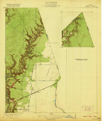
 1916 Huffman1916 Print · USGSThe Harris and Liberty County border comes into focus during the early twentieth century as a landscape of bayous and rails. Genealogists can trace the early layout of Huffman and the path of the Beaumont Sour Lake and Western railroad near Luce Bayou.3 unique versions available
 - 1920 Map of Huffman
 1920 Huffman1920 Print · USGSCoastal prairie and timberlands north of Houston come into focus during the early twentieth century as a burgeoning rail and road network took shape. Genealogists can trace family landmarks and early transit routes through Huffman, Scott Ranch, and the Lumber R R.2 unique versions available
 - 1954 Map of Beaumont, 1964 Print
 1954 Beaumont1964 Print · USGSSoutheast Texas in the mid-fifties reveals a landscape of massive national forests, emerging reservoirs, and a booming oil economy. Genealogists and researchers can trace rural settlements like Dallardsville and Village Mills or locate early drilling sites at Sour Lake Oil Field.3 unique versions available
 - 1957 Map of Beaumont
 1957 Beaumont1957 Print · USGSSoutheast Texas in the mid-fifties is defined by the timber-rich lands between the Trinity River and Beaumont. Trace the history of the Alabama and Coushatti Indian Reservation or locate early campus sites like Prairie View College.
 - 1960 Map of Huffman, 1962 Print
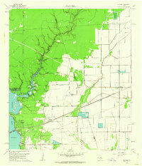 1960 Huffman1962 Print · USGSNortheast Harris County in the early sixties was a landscape of bayous and rail lines at the edge of the rising Houston Lake. Genealogists and local historians can trace the foundations of Huffman, locating the Huffman School, St Annes Church, and the historic Atascocita Road.4 unique versions available
 - 1984 Map of Beaumont
 1984 Beaumont1984 Print · USGSSoutheast Texas in the late seventies and early eighties shows a landscape of expanding reservoirs and deep timber industry. Researchers can trace the development of the Sam Houston National Forest or locate regional landmarks like Grabbs Prairie and the Wynne State Prison Farm.3 unique versions available
 - 1985 Map of Conroe
 1985 Conroe1985 Print · USGSSoutheast Texas in the mid-eighties shows a landscape of timberlands and new lakeside developments. Researchers can trace the legacy of rail lines like the Southern Pacific RR or locate rural communities such as Plantersville, Yarboro, and Hufsmith.2 unique versions available
End of results
Showing maps 1-7 of 7
Top cities near Lakewood Heights
- Houston historical maps
- Atascocita historical maps
- Kingwood historical maps
- Baytown historical maps
- Humble historical maps
- Highlands historical maps
See more
Frequently asked questions
- What are the different types of historical maps available for Lakewood Heights?
- What is the oldest map of Lakewood Heights?
- Where can I purchase historical maps of Lakewood Heights for my home or office?
- Where can I download high-res historical maps of Lakewood Heights?
- Are there historical topographic maps available for Lakewood Heights?
- Is there historical aerial imagery available for Lakewood Heights?
- Where are historical maps of Lakewood Heights sourced from?