1980s Maps of Mahatma Gandhi District, Houston
Explore 2 historic maps of Mahatma Gandhi District from the 1980s. These maps offer a rare glimpse into what life looked like during the 1980s — showing old roads, neighborhoods, homes, and landmarks that have changed or disappeared over time.
Whether you're researching your family's past, planning a metal detecting trip, or studying how Mahatma Gandhi District's landscape evolved across the 1980s, these high-resolution maps are a powerful tool for exploring the history of this region.
- Focus on a specific era: All maps on this page are from the 1980s, giving you a focused view of this time period.
- See what’s changed: Compare century-old streets, trails, and buildings to today's modern landscape using overlays and satellite layers.
- Research with precision: Use these maps for genealogy, historical research, land use analysis, or educational projects.
- View, download, or print: Maps are fully viewable online in high resolution, and can be downloaded or printed for your own records.
Start exploring Mahatma Gandhi District's history through authentic maps from the 1980s. This is your window into the past.
Mahatma Gandhi District, Houston maps
(2)- 1982 Map of Alief
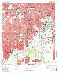
 1982 Alief1982 Print · USGSSouthwest Houston was undergoing a massive suburban transformation in the early eighties. Genealogists and historians can trace the development of Alief and Stafford, or locate family sites near Riceville Cem and Andrau Airpark.2 unique versions available
 - 1982 Map of Bellaire, 1983 Print
 1982 Bellaire1983 Print · USGSSouthwest Houston and Bellaire are shown at a peak of late-century expansion, dominated by new highway loops and major medical hubs. Local historians can trace the development of the Astrodome complex and numerous schools like Madison High Sch and Lamar High Sch.
End of results
Showing maps 1-2 of 2
Frequently asked questions
- What are the different types of historical maps available for Mahatma Gandhi District?
- What is the oldest map of Mahatma Gandhi District?
- Where can I purchase historical maps of Mahatma Gandhi District for my home or office?
- Where can I download high-res historical maps of Mahatma Gandhi District?
- Are there historical topographic maps available for Mahatma Gandhi District?
- Is there historical aerial imagery available for Mahatma Gandhi District?
- Where are historical maps of Mahatma Gandhi District sourced from?