1910s Maps of Yorkwood, Houston
Explore 3 historic maps of Yorkwood from the 1910s. These maps offer a rare glimpse into what life looked like during the 1910s — showing old roads, neighborhoods, homes, and landmarks that have changed or disappeared over time.
Whether you're researching your family's past, planning a metal detecting trip, or studying how Yorkwood's landscape evolved across the 1910s, these high-resolution maps are a powerful tool for exploring the history of this region.
- Focus on a specific era: All maps on this page are from the 1910s, giving you a focused view of this time period.
- See what’s changed: Compare century-old streets, trails, and buildings to today's modern landscape using overlays and satellite layers.
- Research with precision: Use these maps for genealogy, historical research, land use analysis, or educational projects.
- View, download, or print: Maps are fully viewable online in high resolution, and can be downloaded or printed for your own records.
Start exploring Yorkwood's history through authentic maps from the 1910s. This is your window into the past.
Yorkwood, Houston maps
(3)- 1915 Map of Houston Heights
 1915 Houston Heights1915 Print · USGSThe outskirts of Houston are just beginning to take their modern shape in the mid-1910s as new residential grids emerge along the bayous. Genealogists and historians can trace early neighborhood boundaries in Independence Heights and locate vanished rural landmarks like Hohl School and Rosslyn.2 unique versions available
 - 1915 Map of Hillendahl
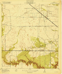
 1915 Hillendahl1915 Print · USGSHarris County west of Houston is captured here during the mid-1910s, showing a rural landscape of schools, creeks, and early rail lines. Genealogists can trace the early community around Hillendahl School and the tracks of the Houston and Texas Central.3 unique versions available
 - 1918 Map of Hillendahl
 1918 Hillendahl1918 Print · USGSHarris County prairie life in the decade before the oil boom is preserved here, showing the rural landscapes west of Houston. Genealogists can trace family roots near the Hillendahl School, Spring Branch School, and early rail stops along the Missouri Kansas and Texas.2 unique versions available
End of results
Showing maps 1-3 of 3
Frequently asked questions
- What are the different types of historical maps available for Yorkwood?
- What is the oldest map of Yorkwood?
- Where can I purchase historical maps of Yorkwood for my home or office?
- Where can I download high-res historical maps of Yorkwood?
- Are there historical topographic maps available for Yorkwood?
- Is there historical aerial imagery available for Yorkwood?
- Where are historical maps of Yorkwood sourced from?