1910s Maps of University Park, Harris County
Explore 2 historic maps of University Park from the 1910s. These maps offer a rare glimpse into what life looked like during the 1910s — showing old roads, neighborhoods, homes, and landmarks that have changed or disappeared over time.
Whether you're researching your family's past, planning a metal detecting trip, or studying how University Park's landscape evolved across the 1910s, these high-resolution maps are a powerful tool for exploring the history of this region.
- Focus on a specific era: All maps on this page are from the 1910s, giving you a focused view of this time period.
- See what’s changed: Compare century-old streets, trails, and buildings to today's modern landscape using overlays and satellite layers.
- Research with precision: Use these maps for genealogy, historical research, land use analysis, or educational projects.
- View, download, or print: Maps are fully viewable online in high resolution, and can be downloaded or printed for your own records.
Start exploring University Park's history through authentic maps from the 1910s. This is your window into the past.
University Park, Harris County maps
(2)- 1915 Map of Addicks
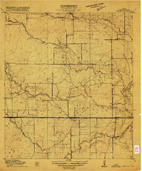 1915 Addicks1915 Print · USGSWestern Harris County was a region of prairie farmsteads and vital rail connections during the mid-1910s. Genealogists can trace early homesteads like the Gertie Rice Farm or locate community centers such as the German Methodist Church and Barker School.3 unique versions available
 - 1918 Map of Addicks
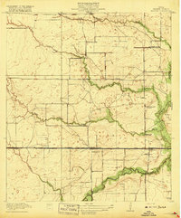 1918 Addicks1918 Print · USGSWestern Harris County is captured here during the first World War as a landscape of prairie farms and early rail settlements. Researchers can trace the Missouri Kansas and Texas railroad to Addicks, find the German Methodist Church, and locate family sites like the Gertie Rice Farm.2 unique versions available
End of results
Showing maps 1-2 of 2
Frequently asked questions
- What are the different types of historical maps available for University Park?
- What is the oldest map of University Park?
- Where can I purchase historical maps of University Park for my home or office?
- Where can I download high-res historical maps of University Park?
- Are there historical topographic maps available for University Park?
- Is there historical aerial imagery available for University Park?
- Where are historical maps of University Park sourced from?