1900s (20th Century) Maps of Dripping Springs, Texas
Explore 13 historic maps of Dripping Springs from the 1900s (20th Century). These maps offer a rare glimpse into what life looked like during the 1900s — showing old roads, neighborhoods, homes, and landmarks that have changed or disappeared over time.
Whether you're researching your family's past, planning a metal detecting trip, or studying how Dripping Springs's landscape evolved across the 1900s, these high-resolution maps are a powerful tool for exploring the history of this region.
- Focus on a specific era: All maps on this page are from the 1900s, giving you a focused view of this time period.
- See what’s changed: Compare century-old streets, trails, and buildings to today's modern landscape using overlays and satellite layers.
- Research with precision: Use these maps for genealogy, historical research, land use analysis, or educational projects.
- View, download, or print: Maps are fully viewable online in high resolution, and can be downloaded or printed for your own records.
Start exploring Dripping Springs's history through authentic maps from the 1900s. This is your window into the past.
Dripping Springs, TX maps
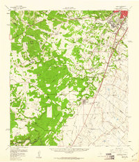
(13)- 1910 Map of Austin
 1910 Austin1910 Print · USGSAustin and the surrounding Travis County hill country are captured here at the start of the twentieth century. Genealogists and researchers can locate pioneer landmarks like Anderson Mill, Mc.Kinney Falls, and numerous river crossings including Lohmann Ford.3 unique versions available
 - 1954 Map of Llano, 1964 Print
 1954 Llano1964 Print · USGSThe Texas Hill Country and Highland Lakes appear in the mid-fifties, just as new reservoirs began reshaping the landscape. Trace ranching history and river routes from Mason to Llano, or follow the Gulf Colorado and Santa Fe RR past Buchanan Lake.2 unique versions available
 - 1954 Map of Austin, 1964 Print
 1954 Austin1964 Print · USGSCentral Texas is captured during a period of steady growth as the capital city and its neighboring farm towns began to modernize. Researchers can trace historic rail corridors like the Southern Pacific RR or locate landmarks such as Bergstrom Air Force Base and Pilot Knob.4 unique versions available
 - 1955 Map of Llano
 1955 Llano1955 Print · USGSCentral Texas and the Hill Country are seen here during the mid-1950s growth of the Highland Lakes. Trace old settlements and geologic landmarks from Enchanted Rock and Longhorn Cavern to the small community of Luckenbach.
 - 1956 Map of Llano, 1976 Print
 1956 Llano1976 Print · USGSThe Texas Hill Country comes alive in this mid-seventies survey of the Llano Uplift and Colorado River lakes. Genealogists and historians can trace family roots through settlements like Luckenbach and Castell or locate the famed L B J Ranch and Enchanted Rock.
 - 1958 Map of Buda, 1960 Print
 1958 Buda1960 Print · USGSBuda and the southern reaches of Travis and Hays Counties are seen here in the late fifties during a period of steady ranching and early suburban growth. Genealogists and local historians can trace family ranch lands and historic sites like Science Hall, Goforth, and the Old San Antonio Road.2 unique versions available
 - 1963 Map of Dripping Springs, 1965 Print
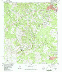
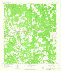 1963 Dripping Springs1965 Print · USGSDripping Springs and the Hays County backcountry are captured in the early sixties as a region of winding creeks and limestone hills. Researchers can trace family history at Fitzhugh Cem and Phillips Cem, or locate landmarks like Camp Ben McCulloch and Walnut Spring.2 unique versions available
 - 1963 Map of Henly, 1965 Print
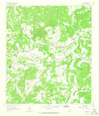 1963 Henly1965 Print · USGSHays County during the early sixties is captured here as a landscape of small family cemeteries and winding creek branches. Genealogists can locate several family plots including Middlebrooks Cem and Moore Cem near the community of Henly.4 unique versions available
 - 1968 Map of Signal Hill, 1971 Print
 1968 Signal Hill1971 Print · USGSTexas ranching life and early suburban development converge on the Travis and Hays county line during the late sixties. Researchers can trace family landmarks like Cedar Valley, Oliver Cem, and legacy properties such as Signal Hill Ranch.3 unique versions available
 - 1985 Map of Austin
 1985 Austin1985 Print · USGSCentral Texas in the mid-eighties reveals a region in transition, balancing rapid urban growth in Austin with deep-rooted rural landscapes. Genealogists and historians can trace family locations near St Johns Ch, the Science Hall schoolhouse, and long-standing communities like Webberville and Manchaca.3 unique versions available
 - 1985 Map of Pedernales River
 1985 Pedernales River1985 Print · USGSThe Texas Hill Country comes alive in the mid-1980s, documenting a landscape of ranching roots and presidential history. Researchers can trace historic settlements like Luckenbach, the presidential grounds of Lyndon B. Johnson National Historic Park, and the early rail path of the Southern Pacific Railroad.2 unique versions available
 - 1986 Map of Signal Hill
 1986 Signal Hill1986 Print · USGSTexas Hill Country terrain meets the growing outskirts of Austin in the mid-1980s. Researchers can locate historic family sites like Oliver Cem, the landmark Friday Mountain, and rural features such as Friendship Ch and the Boys Camp.2 unique versions available
 - 1986 Map of Dripping Springs
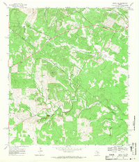
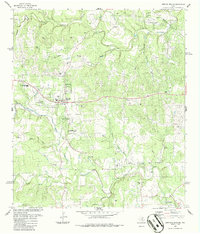 1986 Dripping Springs1986 Print · USGSThe Hill Country around Dripping Springs is captured here during the mid-eighties as local ranching and industry coexisted with community growth. Genealogists and researchers can locate the Fitzhugh Cem, trace the waters of Onion Creek, or find landmarks like Camp Ben McCulloch.
End of results
Showing maps 1-13 of 13
Top cities near Dripping Springs
- Austin historical maps
- Kyle historical maps
- Lakeway historical maps
- Buda historical maps
- Lago Vista historical maps
- Bee Cave historical maps
See more
Frequently asked questions
- What are the different types of historical maps available for Dripping Springs?
- What is the oldest map of Dripping Springs?
- Where can I purchase historical maps of Dripping Springs for my home or office?
- Where can I download high-res historical maps of Dripping Springs?
- Are there historical topographic maps available for Dripping Springs?
- Is there historical aerial imagery available for Dripping Springs?
- Where are historical maps of Dripping Springs sourced from?