1900s (20th Century) Maps of Edna, Texas
Explore 8 historic maps of Edna from the 1900s (20th Century). These maps offer a rare glimpse into what life looked like during the 1900s — showing old roads, neighborhoods, homes, and landmarks that have changed or disappeared over time.
Whether you're researching your family's past, planning a metal detecting trip, or studying how Edna's landscape evolved across the 1900s, these high-resolution maps are a powerful tool for exploring the history of this region.
- Focus on a specific era: All maps on this page are from the 1900s, giving you a focused view of this time period.
- See what’s changed: Compare century-old streets, trails, and buildings to today's modern landscape using overlays and satellite layers.
- Research with precision: Use these maps for genealogy, historical research, land use analysis, or educational projects.
- View, download, or print: Maps are fully viewable online in high resolution, and can be downloaded or printed for your own records.
Start exploring Edna's history through authentic maps from the 1900s. This is your window into the past.
Edna, TX maps
(8)- 1952 Map of Manson, 1953 Print
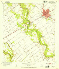
 1952 Manson1953 Print · USGSCoastal Texas prairie meets industrial growth in the early fifties as the oil economy reshaped Jackson County. Trace family roots at Red Bluff Cem or follow the Southern Pacific rail lines through Manson to the Texana Oil Field.3 unique versions available
 - 1952 Map of Edna, 1953 Print
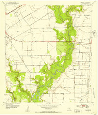
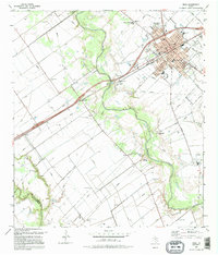
 1952 Edna1953 Print · USGSEdna and the surrounding Texas coastal prairie are captured here in the early fifties during a period of steady civic growth. Local researchers can trace family landmarks like Gideon Ch, locate the historic Site of Camp Independence, and follow the Southern Pacific rail line through El Toro.4 unique versions available
 - 1953 Map of Beeville
 1953 Beeville1953 Print · USGSThe Texas Coastal Bend in the early fifties shows a landscape of growing regional hubs and vital maritime corridors. Trace the rail-and-river economy through Goliad, locate the Matagorda Lighthouse, and explore the sprawling Aransas National Wildlife Refuge.
 - 1956 Map of Beeville
 1956 Beeville1956 Print · USGSCoastal Texas and the brush country interior are shown in the mid-fifties, from the coastal bays to the inland oil fields. Trace the old rail lines of the Southern Pacific RR or locate the historic Matagorda Lighthouse and the Aransas National Wildlife Refuge.2 unique versions available
 - 1960 Map of Beeville
 1960 Beeville1960 Print · USGSCoastal Texas in the mid-fifties reveals a landscape of growing towns and vital military outposts like Foster AFB. Researchers can trace old rail lines including the Missouri Pacific and explore the vast Aransas National Wildlife Refuge.
 - 1984 Map of Port Lavaca
 1984 Port Lavaca1984 Print · USGSCoastal Texas in the mid-1980s reveals a landscape of industrial waterways and historic rail corridors. Genealogists and historians can trace family roots through settlements like Bloomington and La Ward or explore the transit networks of the Southern Pacific and Missouri Pacific.
 - 1995 Map of Manson
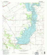 1995 Manson1995 Print · USGSIn the mid-nineties, the Navidad River valley was reshaped by reservoir development and active energy production. Researchers can trace historic burial sites like Sutherland Cem, explore the Lake Texana State Park shoreline, and locate the Manson settlement.
 - 1995 Map of Edna
 1995 Edna1995 Print · USGSCoastal prairie life in Jackson County is centered around Edna during the mid-nineties, where the Lavaca River winds through a landscape of levees and oil fields. Researchers can locate local landmarks like the Gideon Cem, Carver Sch, and the Camp Independence site.
End of results
Showing maps 1-8 of 8
Top cities near Edna
Frequently asked questions
- What are the different types of historical maps available for Edna?
- What is the oldest map of Edna?
- Where can I purchase historical maps of Edna for my home or office?
- Where can I download high-res historical maps of Edna?
- Are there historical topographic maps available for Edna?
- Is there historical aerial imagery available for Edna?
- Where are historical maps of Edna sourced from?