1900s (20th Century) Maps of Williamsburg, Texas
Explore 4 historic maps of Williamsburg from the 1900s (20th Century). These maps offer a rare glimpse into what life looked like during the 1900s — showing old roads, neighborhoods, homes, and landmarks that have changed or disappeared over time.
Whether you're researching your family's past, planning a metal detecting trip, or studying how Williamsburg's landscape evolved across the 1900s, these high-resolution maps are a powerful tool for exploring the history of this region.
- Focus on a specific era: All maps on this page are from the 1900s, giving you a focused view of this time period.
- See what’s changed: Compare century-old streets, trails, and buildings to today's modern landscape using overlays and satellite layers.
- Research with precision: Use these maps for genealogy, historical research, land use analysis, or educational projects.
- View, download, or print: Maps are fully viewable online in high resolution, and can be downloaded or printed for your own records.
Start exploring Williamsburg's history through authentic maps from the 1900s. This is your window into the past.
Williamsburg, TX maps
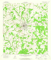
(4)- 1953 Map of Seguin, 1965 Print
 1953 Seguin1965 Print · USGSSouth Texas in the early fifties shows a thriving river-and-rail economy across the Guadalupe and Colorado basins. Genealogists and historians can trace rail routes like the Southern Pacific through Seguin, locate oil wells, or find the Gary AAF near San Marcos.4 unique versions available
 - 1958 Map of Seguin
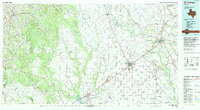
 1958 Seguin1958 Print · USGSSouth Texas in the late fifties was a network of river-valley settlements and active oilfields tied together by major rail lines. Genealogists and historians can trace family-named sites across Rabb Prairie, locate the Behring Store, or follow the Southern Pacific through Schulenburg.
 - 1962 Map of Hallettsville, 1966 Print
 1962 Hallettsville1966 Print · USGSHallettsville and the Lavaca River valley in the early sixties reveal a landscape of rural settlements and emerging industry. Family historians can trace landmarks like Pagel Settlement, the Old County Farm Cemetery, and Light Chapel.2 unique versions available
 - 1994 Map of El Campo
 1994 El Campo1994 Print · USGSCoastal Texas in the mid-nineties shows a landscape deeply shaped by the energy industry and rail logistics. Researchers can trace the sprawling Sheridan Gas Field or locate historic rail stops in El Campo, Spanish Camp, and Provident City.
End of results
Showing maps 1-4 of 4
Top cities near Williamsburg
Frequently asked questions
- What are the different types of historical maps available for Williamsburg?
- What is the oldest map of Williamsburg?
- Where can I purchase historical maps of Williamsburg for my home or office?
- Where can I download high-res historical maps of Williamsburg?
- Are there historical topographic maps available for Williamsburg?
- Is there historical aerial imagery available for Williamsburg?
- Where are historical maps of Williamsburg sourced from?