1900s (20th Century) Maps of Leona, Texas
Explore 9 historic maps of Leona from the 1900s (20th Century). These maps offer a rare glimpse into what life looked like during the 1900s — showing old roads, neighborhoods, homes, and landmarks that have changed or disappeared over time.
Whether you're researching your family's past, planning a metal detecting trip, or studying how Leona's landscape evolved across the 1900s, these high-resolution maps are a powerful tool for exploring the history of this region.
- Focus on a specific era: All maps on this page are from the 1900s, giving you a focused view of this time period.
- See what’s changed: Compare century-old streets, trails, and buildings to today's modern landscape using overlays and satellite layers.
- Research with precision: Use these maps for genealogy, historical research, land use analysis, or educational projects.
- View, download, or print: Maps are fully viewable online in high resolution, and can be downloaded or printed for your own records.
Start exploring Leona's history through authentic maps from the 1900s. This is your window into the past.
Leona, TX maps
(9)- 1953 Map of Palestine, 1964 Print
 1953 Palestine1964 Print · USGSEast Texas was defined by its deep pine forests and burgeoning energy sector in the mid-1950s. Genealogists and historians can trace the rail-and-river economy through settlements like Tennessee Colony and Pollok or explore the early footprints of the Cayuga Oil Field and Davy Crockett National Forest.2 unique versions available
 - 1954 Map of Waco, 1964 Print
 1954 Waco1964 Print · USGSCentral Texas during the mid-fifties shows a landscape defined by the expansion of Fort Hood Military Reservation and the Brazos river system. Trace the rail lines and early airfields like James Connally Air Force Base and settlements like Temple or McGregor.2 unique versions available
 - 1955 Map of Waco
 1955 Waco1955 Print · USGSCentral Texas at the peak of the Cold War reveals a landscape defined by military expansion and major water projects. Researchers can trace the footprints of Fort Hood, the waters of Lake Waco, and regional hubs like Temple or Mexia.
 - 1957 Map of Palestine
 1957 Palestine1957 Print · USGSEast Texas in the mid-fifties reveals a landscape of deep pine forests and winding river valleys before the era of massive reservoir construction. Researchers can trace the legacy of the timber and rail industries through labels for the Missouri Pacific RR, Davy Crockett National Forest, and Nacogdoches.
 - 1964 Map of Spring Seat, 1967 Print
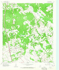
 1964 Spring Seat1967 Print · USGSLeon County's rural landscape is captured in the mid-1960s at a time when the railroad still defined the local geography through Flynn. Researchers can trace old family sites near Spring Creek Cem, Evans Chapel, and the vanished tracks of the F W & D line.2 unique versions available
 - 1964 Map of Leona, 1967 Print
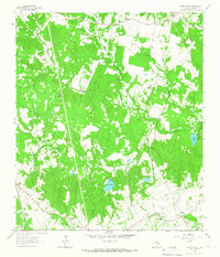
 1964 Leona1967 Print · USGSSettled along the old roads of Leon County in the mid-1960s, this area reveals a landscape of small farms and family cemeteries. Locate local landmarks like Fort Boggy (Site), the Washington Perkins Sch, and the Masumsum Cem.
 - 1984 Map of Palestine
 1984 Palestine1984 Print · USGSEast Texas in the mid-eighties reveals a landscape of massive reservoirs and protected timberlands between Palestine and Nacogdoches. Researchers can trace old routes like the Missouri Pacific RR and locate rural communities such as Tennessee Colony, Latexo, and Etoile.3 unique versions available
 - 1985 Map of Marlin
 1985 Marlin1985 Print · USGSMid-century Texas agriculture and transit converge here during the mid-1980s, centered on the Brazos River corridor. Genealogists can locate family sites near Tidwell Prairie or trace the Missouri Pacific RR through Bremond and Kosse.2 unique versions available
 - 1985 Map of Crockett
 1985 Crockett1985 Print · USGSEast Texas timber and river country are captured here during the mid-eighties, showing the region's transition into the modern era. Genealogists and historians can trace the Old San Antonio Road and locate rural landmarks like Hazel Chapel or Weldon Cem.2 unique versions available
End of results
Showing maps 1-9 of 9
Top cities near Leona
Frequently asked questions
- What are the different types of historical maps available for Leona?
- What is the oldest map of Leona?
- Where can I purchase historical maps of Leona for my home or office?
- Where can I download high-res historical maps of Leona?
- Are there historical topographic maps available for Leona?
- Is there historical aerial imagery available for Leona?
- Where are historical maps of Leona sourced from?