1900s (20th Century) Maps of Rosita, Texas
Explore 5 historic maps of Rosita from the 1900s (20th Century). These maps offer a rare glimpse into what life looked like during the 1900s — showing old roads, neighborhoods, homes, and landmarks that have changed or disappeared over time.
Whether you're researching your family's past, planning a metal detecting trip, or studying how Rosita's landscape evolved across the 1900s, these high-resolution maps are a powerful tool for exploring the history of this region.
- Focus on a specific era: All maps on this page are from the 1900s, giving you a focused view of this time period.
- See what’s changed: Compare century-old streets, trails, and buildings to today's modern landscape using overlays and satellite layers.
- Research with precision: Use these maps for genealogy, historical research, land use analysis, or educational projects.
- View, download, or print: Maps are fully viewable online in high resolution, and can be downloaded or printed for your own records.
Start exploring Rosita's history through authentic maps from the 1900s. This is your window into the past.
Rosita, TX maps
(5)- 1940 Map of Eagle Pass, 1959 Print
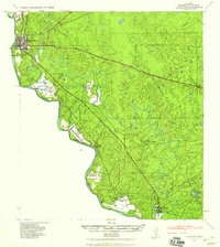 1940 Eagle Pass1959 Print · USGSMaverick County sits along the winding bend of the Rio Grande during the early days of the Second World War. Researchers can trace numerous family-named landmarks and agricultural holdings like Milton Frank Farms, La Rosita Ranch, and the Sullivan Ranch.
 - 1958 Map of Eagle Pass, 1969 Print
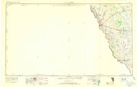 1958 Eagle Pass1969 Print · USGSThe borderlands of South Texas come alive in this mid-century look at the ranching and rail corridor along the Rio Grande. Genealogists and historians can trace legacy holdings like San Pedro Ranch, find the Maverick Canal network, and locate rail sidings at Darling.2 unique versions available
 - 1965 Map of Eagle Pass
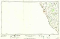 1965 Eagle Pass1965 Print · USGSThe Texas-Mexico borderlands come into focus in the mid-1960s, centered on the river life and ranching culture of Maverick County. Researchers can trace the legacy of major landholdings like Burr Ranch and Loma Linda Ranch alongside landmarks like the Hydroelectric Plant.
 - 1983 Map of Eagle Pass SW
 1983 Eagle Pass SW1983 Print · USGSThe international border along the Rio Grande was a network of small settlements and customs outposts in the early eighties. Researchers can locate El Saucito (Aduana), the deserted site at Santo Domingo (Abandonado), and the course of the Maverick County Canal.
 - 1985 Map of Eagle Pass
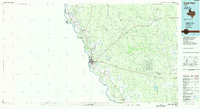 1985 Eagle Pass1985 Print · USGSThe Texas-Mexico borderlands come into focus in the mid-1980s as Eagle Pass grows along the Rio Grande. Genealogists and historians can trace the rail corridor of the Southern Pacific and locate rural communities like Normandy and El Indio.
End of results
Showing maps 1-5 of 5
Top cities near Rosita
- Eagle Pass historical maps
- Chula Vista historical maps
- Las Quintas Fronterizas historical maps
- El Indio historical maps
Frequently asked questions
- What are the different types of historical maps available for Rosita?
- What is the oldest map of Rosita?
- Where can I purchase historical maps of Rosita for my home or office?
- Where can I download high-res historical maps of Rosita?
- Are there historical topographic maps available for Rosita?
- Is there historical aerial imagery available for Rosita?
- Where are historical maps of Rosita sourced from?