1900s (20th Century) Maps of Milburn, Texas
Explore 6 historic maps of Milburn from the 1900s (20th Century). These maps offer a rare glimpse into what life looked like during the 1900s — showing old roads, neighborhoods, homes, and landmarks that have changed or disappeared over time.
Whether you're researching your family's past, planning a metal detecting trip, or studying how Milburn's landscape evolved across the 1900s, these high-resolution maps are a powerful tool for exploring the history of this region.
- Focus on a specific era: All maps on this page are from the 1900s, giving you a focused view of this time period.
- See what’s changed: Compare century-old streets, trails, and buildings to today's modern landscape using overlays and satellite layers.
- Research with precision: Use these maps for genealogy, historical research, land use analysis, or educational projects.
- View, download, or print: Maps are fully viewable online in high resolution, and can be downloaded or printed for your own records.
Start exploring Milburn's history through authentic maps from the 1900s. This is your window into the past.
Milburn, TX maps
(6)- 1925 Map of Brady 1-a
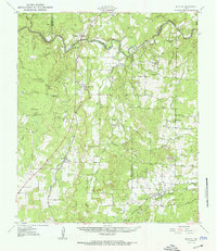
 1925 Brady 1-a1925 Print · USGSCentral Texas river country and ranchland are captured in the mid-1920s as early highway networks began to reach remote crossings. Researchers can locate early rural landmarks like Elm Grove Church, Holt School, and the settlement of Milburn.
 - 1928 Map of Mercury
 1928 Mercury1928 Print · USGSCentral Texas river country comes to life in the late 1920s as the railroad connects small cattle towns near the four-county junction. Trace family roots at Mercury and Winchell, or locate old landmarks like Elm Grove Church and Holt School.
 - 1950 Map of Mercury
 1950 Mercury1950 Print · USGSMcCulloch County and its neighbors are shown in the mid-twentieth century as the rural landscape transitioned from pioneer roots to modern ranching. Researchers can trace family history through community sites like Cowboy Cemetery, Elm Grove School, and the village of Mercury.2 unique versions available
 - 1954 Map of Brownwood, 1955 Print
 1954 Brownwood1955 Print · USGSCentral Texas in the early fifties shows a landscape of rail-linked cattle towns and winding river valleys before modern highway expansion. Genealogists and historians can trace family-named peaks and vanished rail stops like Trickham, Santa Anna, and the Brady Mountains.3 unique versions available
 - 1979 Map of Elm Grove, 1980 Print
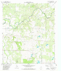 1979 Elm Grove1980 Print · USGSThe ranchlands of San Saba, McCulloch, and Brown counties come into focus in the late 1970s as the Colorado River meanders through the brushy hills. Researchers can locate the Beasley Cemetery, the Elm Grove Ch, and the rural Rodeo Ground.
 - 1985 Map of Brady
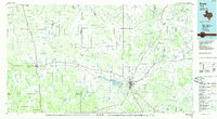 1985 Brady1985 Print · USGSMcCulloch and Concho counties during the mid-1980s show a landscape of small ranching communities tied together by the Atchison Topeka and Santa Fe rail line. Researchers can trace rural developments like West Sweden, Pear Valley, and the waters of the Brady Reservoir.2 unique versions available
End of results
Showing maps 1-6 of 6
Top cities near Milburn
Frequently asked questions
- What are the different types of historical maps available for Milburn?
- What is the oldest map of Milburn?
- Where can I purchase historical maps of Milburn for my home or office?
- Where can I download high-res historical maps of Milburn?
- Are there historical topographic maps available for Milburn?
- Is there historical aerial imagery available for Milburn?
- Where are historical maps of Milburn sourced from?