1960s Maps of Sunset Springs, The Woodlands
Explore 2 historic maps of Sunset Springs from the 1960s. These maps offer a rare glimpse into what life looked like during the 1960s — showing old roads, neighborhoods, homes, and landmarks that have changed or disappeared over time.
Whether you're researching your family's past, planning a metal detecting trip, or studying how Sunset Springs's landscape evolved across the 1960s, these high-resolution maps are a powerful tool for exploring the history of this region.
- Focus on a specific era: All maps on this page are from the 1960s, giving you a focused view of this time period.
- See what’s changed: Compare century-old streets, trails, and buildings to today's modern landscape using overlays and satellite layers.
- Research with precision: Use these maps for genealogy, historical research, land use analysis, or educational projects.
- View, download, or print: Maps are fully viewable online in high resolution, and can be downloaded or printed for your own records.
Start exploring Sunset Springs's history through authentic maps from the 1960s. This is your window into the past.
Sunset Springs, The Woodlands maps
(2)- 1960 Map of Spring, 1962 Print
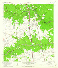 1960 Spring1962 Print · USGSNorthern Harris County is captured here just as the rural oil-and-rail economy began to transition toward modern suburbia. Genealogists can locate family burial sites like Budde Cem and Ehrhardt Cem alongside the old Missouri Pacific line.2 unique versions available
 - 1961 Map of Tamina, 1962 Print
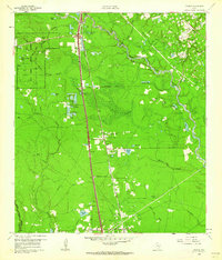 1961 Tamina1962 Print · USGSSouthern Montgomery County in the early sixties is a landscape of timber and oil, dominated by the West Fork San Jacinto River. Researchers can trace the roots of local communities at Tamina, locate family plots in the Tamina Cem, and explore the rail-side growth near Rayford.4 unique versions available
End of results
Showing maps 1-2 of 2
Frequently asked questions
- What are the different types of historical maps available for Sunset Springs?
- What is the oldest map of Sunset Springs?
- Where can I purchase historical maps of Sunset Springs for my home or office?
- Where can I download high-res historical maps of Sunset Springs?
- Are there historical topographic maps available for Sunset Springs?
- Is there historical aerial imagery available for Sunset Springs?
- Where are historical maps of Sunset Springs sourced from?