1960s Maps of Sweetwater, Texas
Explore 3 historic maps of Sweetwater from the 1960s. These maps offer a rare glimpse into what life looked like during the 1960s — showing old roads, neighborhoods, homes, and landmarks that have changed or disappeared over time.
Whether you're researching your family's past, planning a metal detecting trip, or studying how Sweetwater's landscape evolved across the 1960s, these high-resolution maps are a powerful tool for exploring the history of this region.
- Focus on a specific era: All maps on this page are from the 1960s, giving you a focused view of this time period.
- See what’s changed: Compare century-old streets, trails, and buildings to today's modern landscape using overlays and satellite layers.
- Research with precision: Use these maps for genealogy, historical research, land use analysis, or educational projects.
- View, download, or print: Maps are fully viewable online in high resolution, and can be downloaded or printed for your own records.
Start exploring Sweetwater's history through authentic maps from the 1960s. This is your window into the past.
Sweetwater, TX maps
(3)- 1969 Map of Busby, 1972 Print
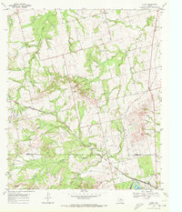 1969 Busby1972 Print · USGSThe Texas rail-and-ranching landscape of the late 1960s comes into focus along the Atchison Topeka and Santa Fe line. Researchers can trace the small sidings of Capitola and Gannon or locate family landmarks near Ray Jones Spring and Wasp Peak.
 - 1969 Map of Sweetwater, 1973 Print
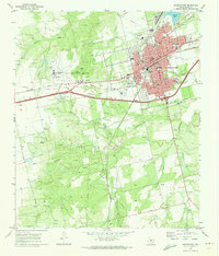 1969 Sweetwater1973 Print · USGSSweetwater thrived as a Texas rail and petroleum center during the late sixties, where the high plains meet industrial growth. Trace the development of Avenger Village near the Municipal Airport or locate the numerous derricks within the Rowan Hope Oil Field.2 unique versions available
 - 1969 Map of Lake Sweetwater, 1973 Print
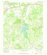 1969 Lake Sweetwater1973 Print · USGSNolan County's landscape in the late sixties centers on the newly developed recreation areas and the industrial rail corridors of the west. Genealogists and historians can trace family sites like Coffee Cem and Garden of Memories Cem alongside the routes of the Texas and Pacific railroad.2 unique versions available
End of results
Showing maps 1-3 of 3
Top cities near Sweetwater
Top neighborhoods of Sweetwater
Frequently asked questions
- What are the different types of historical maps available for Sweetwater?
- What is the oldest map of Sweetwater?
- Where can I purchase historical maps of Sweetwater for my home or office?
- Where can I download high-res historical maps of Sweetwater?
- Are there historical topographic maps available for Sweetwater?
- Is there historical aerial imagery available for Sweetwater?
- Where are historical maps of Sweetwater sourced from?