Old Maps of Gluck, Texas
Explore 11 old maps of Gluck, spanning from 1934 to today. These high-resolution historic maps reveal how streets, neighborhoods, landmarks, and natural features evolved over time — perfect for genealogy, metal detecting, research, and local history exploration.
What you can do with these maps:
- See how Gluck changed over time: Compare historical maps to modern-day views to trace roads, homesites, rail lines & more.
- View detailed metadata: Each map includes creators, publishers, year, scale, and archive source.
- Overlay maps with satellite & LiDAR: Visualize the past alongside modern tools to explore terrain & human change.
- Trusted historical sources: Maps sourced from the USGS, Library of Congress, and other archives.
- Access maps your way: View online, download high-res files, or order prints for personal or research use.
Start exploring old maps of Gluck to uncover forgotten places, hidden landmarks, and the deep history beneath your feet.
Gluck, TX maps
(11)- 1934 Map of Cliffside, 1959 Print
 1934 Cliffside1959 Print · USGSPotter County ranching and rail infrastructure are captured here in the mid-1930s. Genealogists and local historians can trace legacy holdings like Fuqua Ranch and Bivins Ranch alongside rural landmarks like Pleasant Valley Sch.
 - 1936 Map of Cliffside
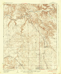 1936 Cliffside1936 Print · USGSPotter County ranching and rail infrastructure are captured here in the mid-1930s as the Panhandle modernized. Researchers can trace family-named landmarks like Fuqua Ranch and Bivins Ranch or locate early rural education sites at River Road Sch.2 unique versions available
 - 1953 Map of Pleasant Valley, 1954 Print
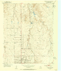 1953 Pleasant Valley1954 Print · USGSNorth of Amarillo in the early fifties, the Panhandle landscape was a mix of cattle ranching, caliche mining, and early suburban growth. Genealogists and local historians can locate family landmarks like Bivins Ranch, the Amarillo Speed-Bowl, and the River Road School.3 unique versions available
 - 1954 Map of Amarillo, 1966 Print
 1954 Amarillo1966 Print · USGSThe Texas Panhandle in the mid-1960s shows a landscape of rising industrial power and deep-rooted ranching tradition. Local historians can trace the paths of the Panhandle and Santa Fe railroad or locate sites like the Pantex Ordnance Plant and Mobeetie.2 unique versions available
 - 1958 Map of Amarillo
 1958 Amarillo1958 Print · USGSThe Texas Panhandle in the mid-1950s reveals a landscape of expanding military installations and oil-rich rail towns. Local historians can trace the development of Amarillo Air Force Base or locate smaller settlements like Magic City and New Mobeetie.
 - 1986 Map of Amarillo
 1986 Amarillo1986 Print · USGSAmarillo and the surrounding Texas Panhandle are captured here in the mid-eighties as a hub of energy, agriculture, and transport. Researchers can trace the sprawling Pantex Plant, the rail-side growth of Panhandle, and the deep cuts of Palo Duro Canyon.2 unique versions available
 - 2010 Map of Pleasant Valley, 2010 Print
 2010 Pleasant Valley2010 Print · USGSCovers Gluck, including Amarillo, Pleasant Valley, and other nearby areas
 - 2012 Map of Pleasant Valley, 2012 Print
 2012 Pleasant Valley2012 Print · USGSCovers Gluck, including Amarillo, Pleasant Valley, and other nearby areas
 - 2016 Map of Pleasant Valley, 2016 Print
 2016 Pleasant Valley2016 Print · USGSCovers Gluck, including Amarillo, Pleasant Valley, and other nearby areas
 - 2019 Map of Pleasant Valley, 2019 Print
 2019 Pleasant Valley2019 Print · USGSCovers Gluck, including Amarillo, Pleasant Valley, and other nearby areas
 - 2022 Map of Pleasant Valley, 2022 Print
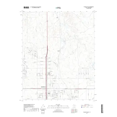
 2022 Pleasant Valley2022 Print · USGSThe northern outskirts of Amarillo and the community of Pleasant Valley are captured here as they appeared in 2022. Researchers can trace the development of the suburban grid into the creek-cut plains near Gluck, Juilliard, and along Indian Creek.
End of results
Showing maps 1-11 of 11
Top cities near Gluck
Frequently asked questions
- What are the different types of historical maps available for Gluck?
- What is the oldest map of Gluck?
- Where can I purchase historical maps of Gluck for my home or office?
- Where can I download high-res historical maps of Gluck?
- Are there historical topographic maps available for Gluck?
- Is there historical aerial imagery available for Gluck?
- Where are historical maps of Gluck sourced from?