1990s Maps of Pointblank, Point Blank
Explore 1 historic maps of Pointblank from the 1990s. These maps offer a rare glimpse into what life looked like during the 1990s — showing old roads, neighborhoods, homes, and landmarks that have changed or disappeared over time.
Whether you're researching your family's past, planning a metal detecting trip, or studying how Pointblank's landscape evolved across the 1990s, these high-resolution maps are a powerful tool for exploring the history of this region.
- Focus on a specific era: All maps on this page are from the 1990s, giving you a focused view of this time period.
- See what’s changed: Compare century-old streets, trails, and buildings to today's modern landscape using overlays and satellite layers.
- Research with precision: Use these maps for genealogy, historical research, land use analysis, or educational projects.
- View, download, or print: Maps are fully viewable online in high resolution, and can be downloaded or printed for your own records.
Start exploring Pointblank's history through authentic maps from the 1990s. This is your window into the past.
Pointblank, Point Blank maps
(1)- 1997 Map of Stephen Creek, 2000 Print
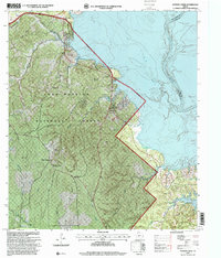 1997 Stephen Creek2000 Print · USGSThe woodlands of San Jacinto County meet the vast waters of the Trinity River in the late nineties, just as the regional landscape was being modernised. Genealogists can locate several remote burial sites such as Jarrell Cem and Carter Cemetery or trace the rural roads connecting Pointblank and Snow Hill.
End of results
Showing maps 1-1 of 1
Top cities near Pointblank
Frequently asked questions
- What are the different types of historical maps available for Pointblank?
- What is the oldest map of Pointblank?
- Where can I purchase historical maps of Pointblank for my home or office?
- Where can I download high-res historical maps of Pointblank?
- Are there historical topographic maps available for Pointblank?
- Is there historical aerial imagery available for Pointblank?
- Where are historical maps of Pointblank sourced from?