1900s (20th Century) Maps of Stamford, Texas
Explore 10 historic maps of Stamford from the 1900s (20th Century). These maps offer a rare glimpse into what life looked like during the 1900s — showing old roads, neighborhoods, homes, and landmarks that have changed or disappeared over time.
Whether you're researching your family's past, planning a metal detecting trip, or studying how Stamford's landscape evolved across the 1900s, these high-resolution maps are a powerful tool for exploring the history of this region.
- Focus on a specific era: All maps on this page are from the 1900s, giving you a focused view of this time period.
- See what’s changed: Compare century-old streets, trails, and buildings to today's modern landscape using overlays and satellite layers.
- Research with precision: Use these maps for genealogy, historical research, land use analysis, or educational projects.
- View, download, or print: Maps are fully viewable online in high resolution, and can be downloaded or printed for your own records.
Start exploring Stamford's history through authentic maps from the 1900s. This is your window into the past.
Stamford, TX maps
(10)- 1954 Map of Abilene, 1966 Print
 1954 Abilene1966 Print · USGSThe Texas Big Country comes into focus in the mid-1950s as petroleum and new water projects reshape the landscape. Local historians can trace the Butterfield Trail, find the Fort Phantom Hill Ruins, and locate numerous small communities along the Texas & Pacific line.2 unique versions available
 - 1954 Map of Wichita Falls, 1966 Print
 1954 Wichita Falls1966 Print · USGSNorth Texas in the mid-fifties is captured here as a landscape of expanding oil fields and vital rail corridors. Genealogists and historians can trace family roots through rural landmarks like Bacon Chapel and the rail-side growth of Seymour and Archer City.3 unique versions available
 - 1958 Map of Wichita Falls
 1958 Wichita Falls1958 Print · USGSNorth Texas during the late fifties reveals a landscape defined by the booming petroleum industry and established rail hubs. Researchers can trace the development of Wichita Falls and discover rural landmarks like Barton's Chapel or the Hull-Silk Oil Field.
 - 1958 Map of Abilene
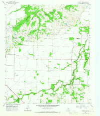
 1958 Abilene1958 Print · USGSMid-century West Texas comes alive in this survey of the Abilene and Stephenville region during a period of steady oil expansion and military growth. Genealogists and local historians can trace the paths of the Texas & Pacific RR through historic towns, locate the Fort Griffin Ruins, and find smaller settlements like Desdemona and Lueders.
 - 1965 Map of Lueders NW, 1967 Print
 1965 Lueders NW1967 Print · USGSAgricultural and industrial life in the Texas Big Country comes into focus in the mid-sixties at the Jones and Haskell county line. Researchers can trace rural community landmarks like Bethel Cem, the local Cotton Gin, and the Missouri Kansas Texas rail line.
 - 1965 Map of Stamford, 1967 Print
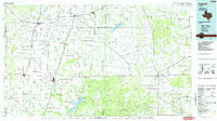
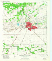 1965 Stamford1967 Print · USGSStamford in the mid-sixties served as a vital West Texas rail junction where the Fort Worth and Denver met the Missouri Kansas Texas line. Researchers can locate specific family sites near the Texas Cowboy Reunion Grounds, Stamford Cem, and local landmarks like Washington Sch.
 - 1966 Map of Lake Stamford East, 1969 Print
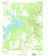 1966 Lake Stamford East1969 Print · USGSHaskell County's hydraulic and energy landscape comes into focus during the mid-sixties, centered on the newly managed waters of Lake Stamford. Researchers can trace early oil exploration via Drill Holes or locate community landmarks like Scott Memorial Park and Scott Crossing.2 unique versions available
 - 1966 Map of Lake Stamford West, 1969 Print
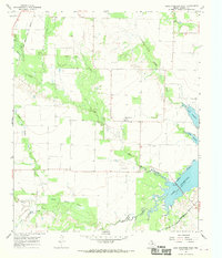 1966 Lake Stamford West1969 Print · USGSHaskell County's landscape in the mid-1960s reveals a rural Texas territory defined by the expanding waters of Lake Stamford and the Haskell Oil Field. Genealogists and historians can trace the Howard Cem and the settlement at Paint Creek during an era of petroleum exploration.
 - 1985 Map of Haskell
 1985 Haskell1985 Print · USGSIn the mid-eighties, this West Texas region highlights a robust agricultural and petroleum economy centered on Haskell and Throckmorton. Trace rail history along the Burlington Northern or locate family roots near Goree and Throckmorton Cem.2 unique versions available
 - 1985 Map of Stamford, 1992 Print
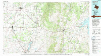 1985 Stamford1992 Print · USGSMid-century West Texas comes alive in this survey of the Brazos River country, showing a landscape defined by oil production and rail transport. Researchers can locate family landmarks like the Avoca Sch, New Hope Ch, and the frontier history at Fort Griffin State Park.
End of results
Showing maps 1-10 of 10
Top cities near Stamford
Frequently asked questions
- What are the different types of historical maps available for Stamford?
- What is the oldest map of Stamford?
- Where can I purchase historical maps of Stamford for my home or office?
- Where can I download high-res historical maps of Stamford?
- Are there historical topographic maps available for Stamford?
- Is there historical aerial imagery available for Stamford?
- Where are historical maps of Stamford sourced from?