1960s Maps of Rio Grande City, Texas
Explore 3 historic maps of Rio Grande City from the 1960s. These maps offer a rare glimpse into what life looked like during the 1960s — showing old roads, neighborhoods, homes, and landmarks that have changed or disappeared over time.
Whether you're researching your family's past, planning a metal detecting trip, or studying how Rio Grande City's landscape evolved across the 1960s, these high-resolution maps are a powerful tool for exploring the history of this region.
- Focus on a specific era: All maps on this page are from the 1960s, giving you a focused view of this time period.
- See what’s changed: Compare century-old streets, trails, and buildings to today's modern landscape using overlays and satellite layers.
- Research with precision: Use these maps for genealogy, historical research, land use analysis, or educational projects.
- View, download, or print: Maps are fully viewable online in high resolution, and can be downloaded or printed for your own records.
Start exploring Rio Grande City's history through authentic maps from the 1960s. This is your window into the past.
Rio Grande City, TX maps
(3)- 1962 Map of McAllen
 1962 McAllen1962 Print · USGSThe Lower Rio Grande Valley in the mid-twentieth century shows a complex landscape of irrigation, oil production, and border commerce. Genealogists and historians can trace family roots through riverside towns like Zapata, Roma-Los Saenz, and Hidalgo, or locate landmarks like Santa Elena Ch and Moore Air Force Base.
 - 1965 Map of Rio Grande City South
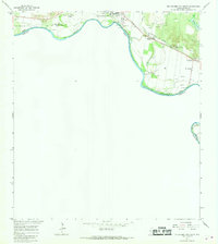 1965 Rio Grande City South1965 Print · USGSAlong the international border in the mid-sixties, this area of southern Starr County shows a landscape of river-bend settlements and early oil exploration. Genealogists can locate family landmarks like Santa Cruz and El Refugio or trace the Missouri Pacific rail line.2 unique versions available
 - 1965 Map of Rio Grande City North, 1968 Print
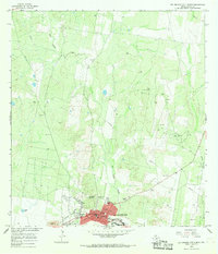 1965 Rio Grande City North1968 Print · USGSRio Grande City during the mid-1960s shows a fascinating mix of traditional town life and the expanding South Texas oil and gas industry. Trace the historic street grid from Main Plaza to West Sch, or explore the outlying landscape marked by an Old Railroad Grade and Kelsey Lake.2 unique versions available
End of results
Showing maps 1-3 of 3
Top cities near Rio Grande City
Top neighborhoods of Rio Grande City
- Loma Alta Colonia historical maps
- Los Olmos Colonia historical maps
- Mitchell Colonia historical maps
- Olivarez Colonia historical maps
- Reyna Colonia historical maps
- Arredondo Colonia historical maps
See more
Frequently asked questions
- What are the different types of historical maps available for Rio Grande City?
- What is the oldest map of Rio Grande City?
- Where can I purchase historical maps of Rio Grande City for my home or office?
- Where can I download high-res historical maps of Rio Grande City?
- Are there historical topographic maps available for Rio Grande City?
- Is there historical aerial imagery available for Rio Grande City?
- Where are historical maps of Rio Grande City sourced from?