1960s Maps of Bee Cave, Texas
Explore 2 historic maps of Bee Cave from the 1960s. These maps offer a rare glimpse into what life looked like during the 1960s — showing old roads, neighborhoods, homes, and landmarks that have changed or disappeared over time.
Whether you're researching your family's past, planning a metal detecting trip, or studying how Bee Cave's landscape evolved across the 1960s, these high-resolution maps are a powerful tool for exploring the history of this region.
- Focus on a specific era: All maps on this page are from the 1960s, giving you a focused view of this time period.
- See what’s changed: Compare century-old streets, trails, and buildings to today's modern landscape using overlays and satellite layers.
- Research with precision: Use these maps for genealogy, historical research, land use analysis, or educational projects.
- View, download, or print: Maps are fully viewable online in high resolution, and can be downloaded or printed for your own records.
Start exploring Bee Cave's history through authentic maps from the 1960s. This is your window into the past.
Bee Cave, TX maps
(2)- 1967 Map of Shingle Hills, 1970 Print
 1967 Shingle Hills1970 Print · USGSThe Travis and Hays County line crosses this central Texas landscape in the late sixties, where the hills meet the waters of Lake Travis. Family researchers and local historians can locate the Peryear Cem, the Shield Ranch Landing Strip, and springs like Bell Spring.
 - 1968 Map of Bee Cave, 1971 Print
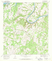 1968 Bee Cave1971 Print · USGSIn the Texas Hill Country during the late sixties, the landscape around Bee Cave was shifting from quiet ranchland to a lakeside retreat. Genealogists and researchers can trace family lines through the White Rock Cem or locate the historic Trading Post and Shield Ranch.3 unique versions available
End of results
Showing maps 1-2 of 2
Top cities near Bee Cave
- Austin historical maps
- Round Rock historical maps
- Cedar Park historical maps
- Leander historical maps
- Lakeway historical maps
- Buda historical maps
See more
Top neighborhoods of Bee Cave
Frequently asked questions
- What are the different types of historical maps available for Bee Cave?
- What is the oldest map of Bee Cave?
- Where can I purchase historical maps of Bee Cave for my home or office?
- Where can I download high-res historical maps of Bee Cave?
- Are there historical topographic maps available for Bee Cave?
- Is there historical aerial imagery available for Bee Cave?
- Where are historical maps of Bee Cave sourced from?