Old Maps of Juno, Texas for Genealogy
Trace your family roots with 9 historic maps of Juno. These high-res maps reveal old neighborhoods, homesites, landmarks, and streets — helping you uncover where your ancestors lived and how the area evolved over time.
- Explore historic neighborhoods: Identify where your relatives may have lived in the 1800s or 1900s.
- Compare maps over time: Trace the changes in streets, buildings, and landmarks for multi-generational research.
- Perfect for genealogy & ancestry research: Used by family historians and researchers to map out lineage and migration.
These maps are an incredible resource for exploring your personal connection to Juno's past.
Juno, TX maps
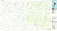
(9)- 1954 Map of Sonora, 1965 Print
 1954 Sonora1965 Print · USGSThe Edwards Plateau and West Texas ranching country come alive in this mid-century survey of the canyons and plateaus. Genealogists and historians can trace the remote settlements of Pandale and Loma Alta or follow the path of the Panhandle and Santa Fe RR.2 unique versions available
 - 1958 Map of Sonora
 1958 Sonora1958 Print · USGSThe Edwards Plateau and Trans-Pecos region come alive in the late fifties, showing a landscape of remote ranchlands and historic frontier outposts. Trace the legacy of Fort Lancaster Ruins, the limestone depths of Devils Sinkhole Cavern, and the path of the Pecos River.
 - 1970 Map of Juno, 1973 Print
 1970 Juno1973 Print · USGSThe high ranch country of West Texas comes into focus in the 1970s, where life centered on the Devils River. Researchers can trace the water sources and ranch boundaries of the era, from the Beaver Lake Ranch to the remote White Well.
 - 1985 Map of Devils Draw, 1986 Print
 1985 Devils Draw1986 Print · USGSThe Pecos and Devils River country of Southwest Texas is captured in the mid-eighties before modern developments. Researchers can trace the Southern Pacific RR through Terrell Station or locate remote outposts like Pandale and Juno.2 unique versions available
 - 2010 Map of Juno, 2010 Print
 2010 Juno2010 Print · USGSCovers Juno, including Val Verde County, United States, and other nearby areas
 - 2012 Map of Juno, 2012 Print
 2012 Juno2012 Print · USGSCovers Juno, including Val Verde County, United States, and other nearby areas
 - 2016 Map of Juno, 2016 Print
 2016 Juno2016 Print · USGSCovers Juno, including Val Verde County, United States, and other nearby areas
 - 2019 Map of Juno, 2019 Print
 2019 Juno2019 Print · USGSCovers Juno, including Val Verde County, United States, and other nearby areas
 - 2022 Map of Juno, 2022 Print
 2022 Juno2022 Print · USGSThe West Texas desert near the Devils River comes into focus in this contemporary survey of a historic ranching crossroads. Researchers can trace the legacy of early settlements through Juno Springs, the local Juno Cemetery, and the deep cuts of Pecos Canyon.
End of results
Showing maps 1-9 of 9
Frequently asked questions
- What are the different types of historical maps available for Juno?
- What is the oldest map of Juno?
- Where can I purchase historical maps of Juno for my home or office?
- Where can I download high-res historical maps of Juno?
- Are there historical topographic maps available for Juno?
- Is there historical aerial imagery available for Juno?
- Where are historical maps of Juno sourced from?