Old Maps of Langtry, Texas for Hiking & Exploration
Hike through history with 10 historic maps of Langtry. Explore old trails, ghost towns, and forgotten backroads — perfect for outdoor adventurers and local explorers.
- Rediscover forgotten places: Map out old mining camps, roads, and footpaths that no longer exist on modern maps.
- Layer with modern tools: Combine with LiDAR or satellite views to plan hikes through historical terrain.
- Made for exploration: Popular among hikers, overlanders, and local history lovers.
Use these maps to find adventure and explore the hidden past of Langtry.
Langtry, TX maps
(10)- 1943 Map of Langtry, 1963 Print
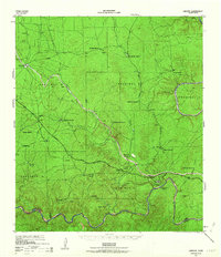 1943 Langtry1963 Print · USGSVal Verde County sits at the confluence of great rivers during the mid-forties, capturing the isolated ranching life of the Trans-Pecos. Researchers can trace the Southern Pacific rail line through Pumpville and Langtry, or locate family landmarks like Rose Ranch and Ingram Ranch.2 unique versions available
 - 1958 Map of Del Rio, 1970 Print
 1958 Del Rio1970 Print · USGSThe Texas-Mexico borderlands come alive in the late fifties, showing the confluence of the Rio Grande and the emerging Amistad Reservoir. Trace the lineage of the Southern Pacific rail line through stops at Pumpville, Shumla, and the mining vicinity of Blewett.2 unique versions available
 - 1964 Map of Del Rio
 1964 Del Rio1964 Print · USGSAlong the Mexican border during the mid-sixties, this area centered on the confluence of the Rio Grande and Devils River. Researchers can trace the Southern Pacific line through isolated stops like Pumpville or locate military and industrial sites such as Laughlin Air Force Base and the mines at Blewett.
 - 1973 Map of Langtry, 1975 Print
 1973 Langtry1975 Print · USGSLangtry and the surrounding borderlands appear in the early seventies, shortly after the flooding of the Amistad Reservoir. Genealogists and rail historians can trace the Babb Cem, the Billings Ranch, and the winding Old Southern Pacific Railroad Grade.
 - 1985 Map of Comstock, 1986 Print
 1985 Comstock1986 Print · USGSVal Verde County was a landscape of deep canyons and borderland outposts in the mid-1980s. Local researchers can trace the Southern Pacific rail line through Langtry and Pumpville or locate landmarks like Big Tree Cave.2 unique versions available
 - 2010 Map of Langtry, 2010 Print
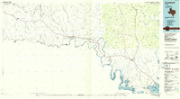
 2010 Langtry2010 Print · USGSCovers Langtry, including Acuña, Val Verde County, and other nearby areas
 - 2013 Map of Langtry, 2013 Print
 2013 Langtry2013 Print · USGSCovers Langtry, including Acuña, Val Verde County, and other nearby areas
 - 2016 Map of Langtry, 2016 Print
 2016 Langtry2016 Print · USGSCovers Langtry, including Acuña, Val Verde County, and other nearby areas
 - 2019 Map of Langtry, 2019 Print
 2019 Langtry2019 Print · USGSCovers Langtry, including Acuña, Val Verde County, and other nearby areas
 - 2022 Map of Langtry, 2022 Print
 2022 Langtry2022 Print · USGSThe borderlands along the Rio Grande near the Pecos River confluence are shown in this recent survey. You can trace the proximity of Langtry to the winding river canyons and the seasonal flow of Eagle Nest Cr as it descends toward the international boundary.
End of results
Showing maps 1-10 of 10
Frequently asked questions
- What are the different types of historical maps available for Langtry?
- What is the oldest map of Langtry?
- Where can I purchase historical maps of Langtry for my home or office?
- Where can I download high-res historical maps of Langtry?
- Are there historical topographic maps available for Langtry?
- Is there historical aerial imagery available for Langtry?
- Where are historical maps of Langtry sourced from?