1970s Maps of Wichita Falls, Texas
Explore 2 historic maps of Wichita Falls from the 1970s. These maps offer a rare glimpse into what life looked like during the 1970s — showing old roads, neighborhoods, homes, and landmarks that have changed or disappeared over time.
Whether you're researching your family's past, planning a metal detecting trip, or studying how Wichita Falls's landscape evolved across the 1970s, these high-resolution maps are a powerful tool for exploring the history of this region.
- Focus on a specific era: All maps on this page are from the 1970s, giving you a focused view of this time period.
- See what’s changed: Compare century-old streets, trails, and buildings to today's modern landscape using overlays and satellite layers.
- Research with precision: Use these maps for genealogy, historical research, land use analysis, or educational projects.
- View, download, or print: Maps are fully viewable online in high resolution, and can be downloaded or printed for your own records.
Start exploring Wichita Falls's history through authentic maps from the 1970s. This is your window into the past.
Wichita Falls, TX maps
(2)- 1972 Map of Wichita Falls West, 1975 Print
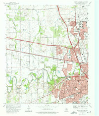 1972 Wichita Falls West1975 Print · USGSWichita Falls is seen in a period of significant mid-century expansion during the early seventies. Genealogists and local historians can trace family plots at Riverside Cemetery or explore the development around Midwestern University and Sheppard Air Force Base.
 - 1972 Map of Wichita Falls East, 1976 Print
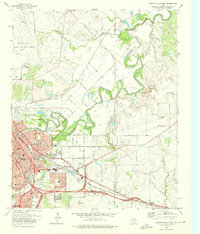 1972 Wichita Falls East1976 Print · USGSWichita Falls and the surrounding valley are shown here in the early seventies during a period of steady urban and military expansion. Researchers can trace the footprints of Sheppard Air Force Base, find the Kempner Cem, and locate neighborhood schools like Holland Sch.2 unique versions available
End of results
Showing maps 1-2 of 2
Top cities near Wichita Falls
- Burkburnett historical maps
- Iowa Park historical maps
- Holliday historical maps
- Lakeside City historical maps
- Dean historical maps
- Pleasant Valley historical maps
See more
Top neighborhoods of Wichita Falls
Frequently asked questions
- What are the different types of historical maps available for Wichita Falls?
- What is the oldest map of Wichita Falls?
- Where can I purchase historical maps of Wichita Falls for my home or office?
- Where can I download high-res historical maps of Wichita Falls?
- Are there historical topographic maps available for Wichita Falls?
- Is there historical aerial imagery available for Wichita Falls?
- Where are historical maps of Wichita Falls sourced from?