1900s (20th Century) Maps of Escobas, Texas
Explore 5 historic maps of Escobas from the 1900s (20th Century). These maps offer a rare glimpse into what life looked like during the 1900s — showing old roads, neighborhoods, homes, and landmarks that have changed or disappeared over time.
Whether you're researching your family's past, planning a metal detecting trip, or studying how Escobas's landscape evolved across the 1900s, these high-resolution maps are a powerful tool for exploring the history of this region.
- Focus on a specific era: All maps on this page are from the 1900s, giving you a focused view of this time period.
- See what’s changed: Compare century-old streets, trails, and buildings to today's modern landscape using overlays and satellite layers.
- Research with precision: Use these maps for genealogy, historical research, land use analysis, or educational projects.
- View, download, or print: Maps are fully viewable online in high resolution, and can be downloaded or printed for your own records.
Start exploring Escobas's history through authentic maps from the 1900s. This is your window into the past.
Escobas, TX maps
(5)- 1940 Map of Mogotes Hill
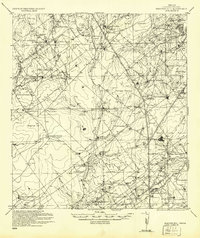 1940 Mogotes Hill1940 Print · USGSZapata County ranching and early petroleum discovery meet in the brush country during the 1940s. Genealogists and historians can trace family landholdings from Trinidad Ranch to Bella Vista Ranch, while locating early industry at Escobas Field and the Cuellar Store.
 - 1956 Map of Mogotes Hill
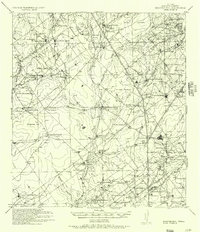 1956 Mogotes Hill1956 Print · USGSZapata County ranching and early oil exploration define this South Texas landscape during the mid-twentieth century. Genealogists can locate family holdings like Salomoneño and Bustamente, alongside the Cuellar Oil Field and Guellar Store.
 - 1956 Map of Laredo, 1960 Print
 1956 Laredo1960 Print · USGSSouth Texas in the mid-fifties reveals a landscape shaped by border commerce, military aviation, and a booming oil industry. Trace the historic Texas and Mexican RR line through Hebbronville or locate the sprawling Mirando City Oil Field and Laredo AFB.3 unique versions available
 - 1980 Map of Escobas
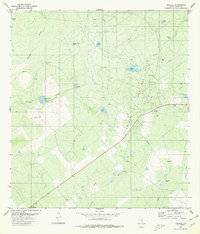 1980 Escobas1980 Print · USGSThe ranching and energy landscape of Zapata County, Texas, is captured here during the 1980s. Researchers can trace remote family burial grounds at Gracia Cem and Camaron Cem or locate the numerous water catchments like Rancho Viejo Tank that supported the local cattle industry.
 - 1985 Map of San Ygnacio
 1985 San Ygnacio1985 Print · USGSThe Rio Grande borderlands and South Texas ranch country are captured here in the mid-eighties as the energy industry expanded inland. Researchers can trace historic river settlements like San Ygnacio or the industrial footprints of Mirando City and the Jennings West Oil and Gas Field.3 unique versions available
End of results
Showing maps 1-5 of 5
Frequently asked questions
- What are the different types of historical maps available for Escobas?
- What is the oldest map of Escobas?
- Where can I purchase historical maps of Escobas for my home or office?
- Where can I download high-res historical maps of Escobas?
- Are there historical topographic maps available for Escobas?
- Is there historical aerial imagery available for Escobas?
- Where are historical maps of Escobas sourced from?